Record Heat Again Today - Windy/Dusty Wednesday-Friday - T-Storms Next Weekend?
Capitan Mountains.
Looking Southeast From St Hwy 246.
Record April Heat Yesterday & Again Today.
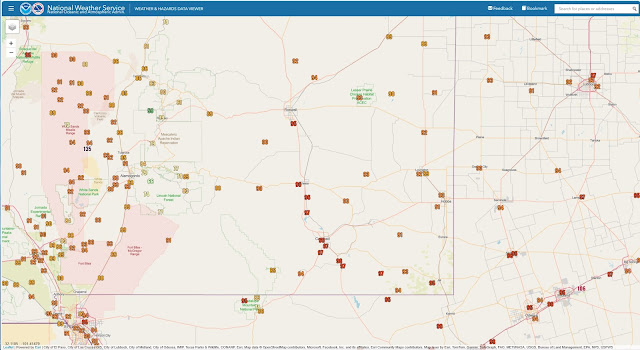
A week ago yesterday (Saturday afternoon, April 5th) light to moderate snow was falling at our home in Carlsbad with a temp of 33 and northeasterly winds gusting to 50 mph. I recorded a high temp here at our home in northwest Carlsbad of 99 Saturday afternoon. You gotta love New Mexico's (or not) crazy weather swings in the spring.
The official high at the Carlsbad Airport ASOS was 97 which broke their record high temp for the date of 93 set in 2018. The Carlsbad Climate Co-Op Station recorded a high of 96 in 2018.
The Roswell Airport ASOS recorded a high temp Saturday afternoon of 95 which broke their previous record high for the date of 94 set in 2018. Numerous other locations across New Mexico also broke their daily record high temps Saturday afternoon.
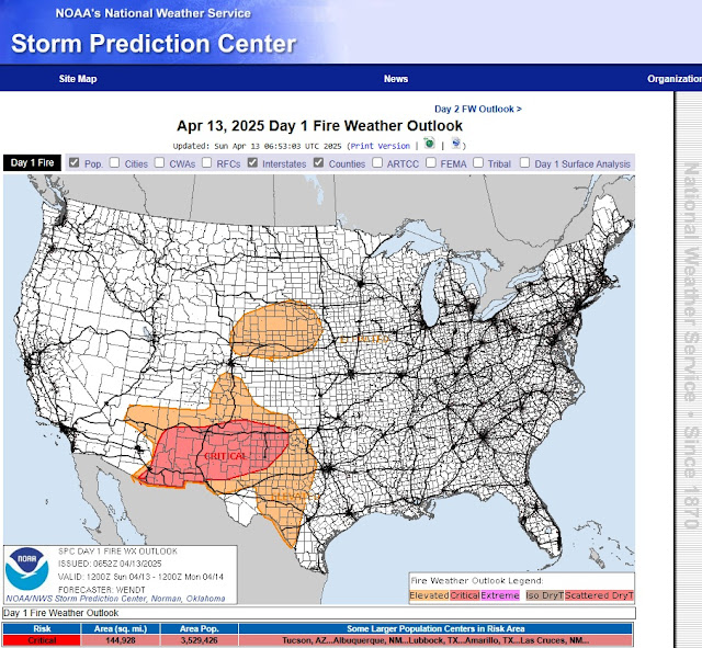
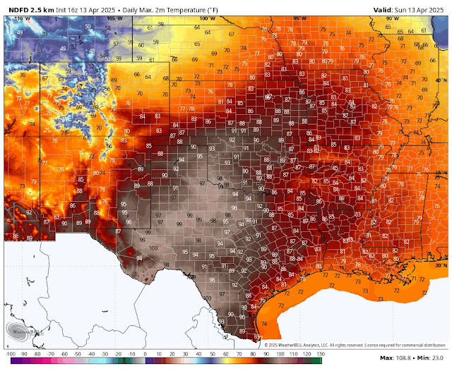
Rinse and repeat again this Sunday afternoon as another day of near to record-breaking heat is forecast across the state and area. Critically dangerous fire weather conditions are forecast today along with gusty westerly winds. Any wildfire that develops will have the ability to rapidly grow and spread.
A backdoor cold front will sink into northeastern New Mexico this afternoon and move south and west into the rest of the state on Monday. High temps will be some ten to twenty degrees behind the front on Monday and Tuesday.
Gusty virga showers along with a few isolated high-based dry thunderstorms will be possible across the western and northern mountains of the state on Monday and Tuesday.
Long-range model forecasts indicate that a strong closed mid-upper level low will swing eastward across Arizona and New Mexico next weekend. Ahead of it, hot and dry strong southwest-to-west winds will kick up areas of blowing dust across the state Wednesday into next Friday.
Isolated to scattered rain showers and thunderstorms will be possible across western, northern, and eastern sections of the state next weekend. We will need to monitor our local weather closely in the eastern sections of the state next weekend given it is the Easter holiday weekend, and there is a chance that the dryline may light up along and near the eastern border, potentially producing a few severe thunderstorms.
Snow will be possible next weekend across the higher elevations of the western and northern mountains. It's too early to tell how much, how widespread, and how low the snow levels will drop with this next strong spring storm.
Today.
(Valid 6 PM MDT Sunday, April 20, 2025).
After just a few months of La Niña conditions, the tropical Pacific is now ENSO-neutral, and forecasters expect neutral to continue through the Northern Hemisphere summer. Neutral is also the most likely state through the fall (greater than 50% chance).
The outlook for the rest of 2025ENSO-neutral is likely through the summer. Chances for El Niño or La Niña increase later in the year, with La Niña chances about double those of El Niño, but neutral is still the highest probability through the early winter.
Forecasts made in the spring are known to be less successful than forecasts made in the rest of the year, an effect called the “spring predictability barrier.” We don’t have a clear understanding of why forecasts are worse this time of year, but one potential culprit is that ENSO tends to be changing phase (e.g., going from La Niña to neutral). For lots more detail on the spring predictability barrier, check out this post and this one on Seasoned Chaos on the topic.
As spring turns to summer, our crystal ball should become clearer. For now, we’ll bid La Niña adieu and bide our time in neutral.
Area Forecast Discussion
National Weather Service Midland/Odessa TX
548 AM CDT Sun Apr 13 2025

...New AVIATION...

.KEY MESSAGES...
Updated at 540 AM CDT Sun Apr 13 2025

- Record-breaking temperatures are expected today before a cold front
  Monday morning brings in cooler weather early this upcoming
  week.

- Near critical fire weather conditions expected this afternoon
  across southeast New Mexico.

- Precipitation chances slim to none before increasing late in the
  week.

&&
Area Forecast Discussion...UPDATED
National Weather Service Albuquerque NM
521 AM MDT Sun Apr 13 2025

...New AVIATION...

.KEY MESSAGES...
Updated at 516 AM MDT Sun Apr 13 2025

- Widespread elevated to critical fire weather is expected through
  Sunday evening with breezy west winds, record warmth, and very
  low humidity. Fire starts will have the potential to spread
  rapidly in receptive fuels.

- Gusty virga showers may develop Monday and Tuesday, especially
  over the higher terrain of western and northern New Mexico.
  Downburst wind gusts and localized blowing dust may occur.

- Another period of very dry and windy conditions may develop
  Wednesday through Friday with high fire danger and areas of
  blowing dust.

&&

.SYNOPSIS...
Issued at 213 AM MDT Sun Apr 13 2025

A very warm to hot Sunday expected across the area today with some
breezy to locally windy conditions across the highlands and eastern
plains this afternoon. These winds combined with the warm to hot
temperatures will result in rapid fire spread for any fire starts
across many areas. Much cooler across eastern NM on Monday behind a
backdoor front. A few high terrain showers and lower elevation
sprinkles across northern areas Tuesday with gusty and erratic wind
gusts being the main hazard. Warmer with breezy southwest to west
winds Wednesday before stronger southwest winds on Thursday. These
stronger winds combined with a very dry and warm airmass will
increase the risk for rapid fire spread once again. Cooler areawide
with potentially wetter weather favoring northern areas this weekend
as a system dives south and moves across the desert southwest.

&&
Area Forecast Discussion
National Weather Service El Paso TX/Santa Teresa NM
548 AM MDT Sun Apr 13 2025

...New AVIATION...

.KEY MESSAGES...
Updated at 543 AM MDT Sun Apr 13 2025

 - We will have near record high temperatures today with windy
   southwest winds.

 - Very dry conditions through much of the work week, low end rain
   chances Friday and into the weekend

 - Winds will be breezy each afternoon except Monday, but the
   windiest day of the period will be Thursday

&&
There Are None So Blind As Those Who "Will - Not" To See...107.


Comments
Post a Comment
Your comments, questions, and feedback on this post/web page are welcome.