Posts

Showing posts from September, 2017

Why Are My Weather Posts Missing From Facebook.

Hello everyone. I just wanted to let you know that my Facebook page was shut down without any warning by Facebook this past Saturday, June 8th. All I was told was that I had violated their community standards. I don't know what triggered that; they didn't tell me. I was told this may be permanent or for six months.
My guess is that it may be because I posted several comments and articles from my Substack page about the riots in LA, and that must have triggered/angered someone, and they complained, thus Facebook shut me down. I don't know this as fact, though. I have appealed this decision, and I'm still waiting for their reply. I have read on X that this has happened to other Facebook users posting about the LA riots as well.
I always share my weather blog posts (that I post here) on my Facebook page and my X page. This included over twelve different New Mexico and West Texas Facebook Community sites. So there are thousands of you out there (based on my views and shares of those posts) who will no longer see those posts. My Facebook page may or may not be restored.
This is another good reason (as the National Weather Service often reminds us) to have multiple ways of receiving severe weather alerts when severe weather threatens your location. My weather web page is one of those ways, and I really appreciate all of you who have and still do use it. Thank you so much!!!
If my Facebook page is restored, I will continue to share my weather blog posts and some of the NWS Watches and Warnings...as I have been doing for years now.

Past Week Has Been Cool & Wet.

Image
Clouds Topping The Guadalupe's. On my way home from work this past Tuesday I was able to capture these two shots looking west along the New Mexico/Texas State line (east of US Hwy 62/180) at clouds topping the Guadalupe Mountains.  Wet Past 7-Days. NWS HARP 7-Rainfall Totals. Measured 7-Day Rainfall Totals. New Mexico CoCoRaHS Totals.  NWS MesoWest Totals. NWS Climate Co-Op & ASOS Stations. Carlsbad Climate Co-Op Station. Carlsbad Airport. Artesia Climate Co-Op Station. Roswell Airport. This past week has been a soaker for the eastern one half of New Mexico including the Southeastern Plains. As of 9 AM MDT this morning the heaviest 7-Day rainfall total I can come up with in the local area is 5.59" measured at the Portales CoCoRaHS Station located 5.1 miles south-southwest of town. The Texico CoCoRaHS Station located 13.6 miles north...

Flash Flooding In Dark Canyon Monday - More Flooding Possible!

Image
Blog Updated At 7:14 AM MDT. 24-Hour Radar Estimated Rainfall Totals. (As Of 6 AM MDT This Morning). Midland NWS Dual Pol Doppler Radar. (Using GRLevelX Software). NWS AHPS River Observations. Radar estimated that 4.50" of rain fell over the Dark Canyon Arroyo 12 miles west of Whites City yesterday morning. This produced flash flooding in Dark Canyon. The Dark Canyon flood gauge located north of Whites City and southwest of Carlsbad measured a maximum water depth in the normally dry arroyo of 6.15 feet at 11:15 AM MDT Monday morning. By the time the flood waters worked their way northeastward into Carlsbad the Dark Canyon flood gauge located near the low water crossing bridge on San Jose Blvd measured a peak depth of 3.9 feet at 8:30 AM MDT yesterday. This falls way short of the flooding that was observed in September of 2014 when water depths exceeded 20 feet at the gauge in town.  3-Day Radar Estimated Rainfall Totals. ...

More Hail Damage Photos Near Washington Ranch From Saturday Evening.

Image
Photos Are Courtesy Of Janet Mayes Of Carlsbad, NM. More photos of of the hail damage from a couple of miles north of the NM/TX State line north of U.S. Hwy 62/180 near the Washington Ranch area Saturday around 6:15 PM MDT. Additional photos and information on this storm can be viewed via this link- Supercell Thunderstorms Roam The High Desert Saturday. Quote From Janet Mayes- " Storm damage from last nights storm. Broke the windshields on every vehicle that was not under the carport. Both jeeps, AJ's work truck, and the dump truck. Broke one window in my bedroom and the sky light in the bathroom again. Broken taillights  and running lights on the new camper." The Truth Is Stranger Than Fiction!

Supercell Thunderstorms Roam The High Desert Saturday.

Image
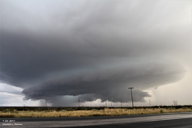
Blog Updated At 8:10 PM MDT. Looking Southeast From Whites City At 6:26 PM MDT Saturday, Sept 23, 2017. My wife jumped into the truck and headed southwest to Whites City Saturday afternoon to chase this supercell thunderstorm pictured above. As impressive as this storm was when I shot this photo it was even more so on radar before we got down there. It had formed a wall cloud but we didn't notice any significant rotation when I took this photo. The storm had already begun to weaken. GRLevel2 Radar Snapshot Of This Supercell Thunderstorm At 5:15 PM MDT. The El Paso/Santa Teresa NWS Office had warned on it for tennis ball size hail shortly before it rolled over the top of the Guadalupe Mountains National Park. At 5:20 PM MDT the Hudspeth County Sheriff reported power lines downed from the storm in Dell City . GRLevel3_2.00 Radar Snapshot At 6:07 PM MDT, The Midland NWS Dual Pol Doppler Radar was indicating that the hail core aloft in the storm had reach...

NWS Albuquerque Burn Scar Matrix

Current National Weather Service Watches/Warnings In Effect.

New Mexico

Chaves County Plains & Mtn's

Eddy County

Culberson County

Lea County

Lincoln County

Otero County

Current US Temps

Current US Wind Chill/Heat Index Temperatures

WPC 7-Day Precipitation Forecast

Roswell Live EarthCam

Ruidoso Live Webcam

Cloudcroft Live Webcam

NWS Midland 3-Day Precipitation Forecast

NWS Midland 3-Precipitation Chances

New Mexico 3-Day Precipitation Forecast

New Mexico Precipitation Chances

NWS El Paso 3-Day Precipitation Forecast

NWS El Paso Precipitation Chances

US 24-Hour Precipitation Forecast

US 3-Day Precipitation Forecast