

Nasty Weather Today - Hot/Dry/Windy/Dusty!
Satellite Images This Morning.

Valid At 4:31 AM MDT.
Water Vapor Image.

Early this morning (Tuesday, Oct 12th) we can see the unusually strong and cold mid-upper level trough of low pressure centered over northern Arizona. Hurricane Pamela was located about 215 miles south-southeast of the southern tip of the Baja Penisula.

GFS 500 Millibar (18,000') Winds.
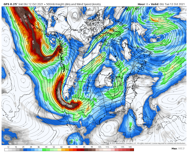
Valid At Midnight Tuesday.
Today's weather will be influenced by the very strong and cold mid-upper level trough of low pressure that is digging into northern Arizona at sunrise this morning. Unusually strong winds at the 18,000' level are rounding the western and southern side of this storm at around 135 mph. This will help deepen the storm as it lifts northeastern into Colorado today.
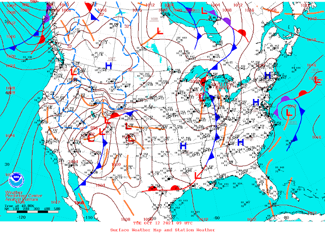
Valid At 3 AM MDT Tuesday, Oct 12, 2021.
Surface Map Forecast.


A Pacific cold front stretched southward from southeastern Utah to northeastern Arizona and into southern Arizona at 3 AM this morning. This front will race eastward across New Mexico today and clear the state by sunset.
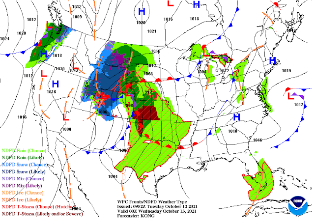
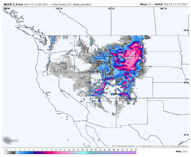
Winter Weather Advisories and Winter Storm Warnings are in effect for parts of Utah, Colorado, Wyoming, Idaho, and Montana. Heavy snows are forecast for some of these locations with up to two feet of snow possible today into tonight.
High Wind Warnings and Wind Advisories cover much of New Mexico and parts of eastern and southeastern Colorado today.
Severe thunderstorms are forecast to develop today from Texas northward into the northern plains. The highest risk for severe weather is expected to be over northern Oklahoma northward into central Nebraska. Large hail, damaging thunderstorm wind gusts, and a few tornadoes will be possible.
Severe thunderstorms will be possible across parts of the Permian Basin of West Texas late this afternoon into this evening. Storms will form along and east of the dryline as the Pacific cold front approaches from the west.
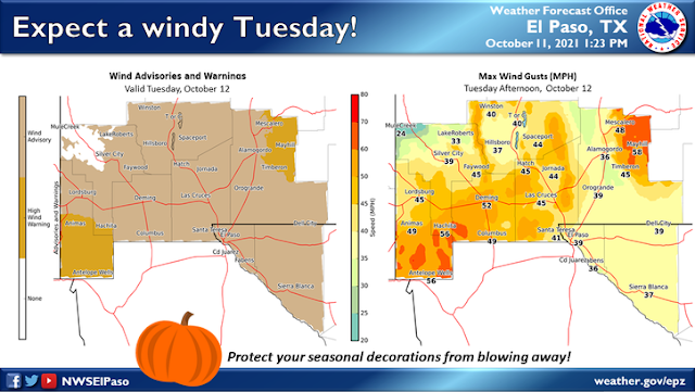
High Winds & Blowing Dust Today.
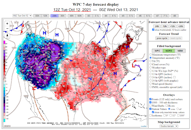
Ahead of the approaching cold front our high temperatures across Southeastern New Mexico and West Texas will average some 5º to 10º above normal for the date. In fact, Carlsbad has a high temp of 90º forecast for today. Behind the cold front, much of the Rockies will average some 25º to 35º below normal.

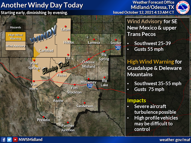

Today is going to be ugly with strong southwesterly winds kicking up later this morning areawide. Hot and dusty conditions are forecast across Southeastern New Mexico with highs in the mid 80's to near 90º.
A High Wind Warning is in effect today through midnight for southwesterly winds increasing to sustained speeds of 35 to 55 mph with gusts near 75 mph across the Guadalupe Mountains.
A High Wind Warning is in effect today into this evening for the Sacramento Mountains including the Ruidoso and Cloudcroft areas. Southwesterly winds are forecast to increase to sustained speeds of around 35 to 45 mph with gusts near 65 mph.
A Wind Advisory covers all of southern New Mexico, Southeastern New Mexico, and much of West Texas for today into this evening. Southwesterly winds are forecast to increase to sustained speeds of around 25 to 45 mph with gusts near 50-55 mph. Some localized stronger gusts will be possible especially with the frontal passage.
Widespread areas of blowing dust are likely today into early this evening. Local areas of blowing dust may suddenly reduce the visibility down to near zero in some locals. This will be especially true near freshly plowed or exposed farmlands, fields, lots, construction sites, and other dust-prone areas. Watch for those tumbleweeds also. Some of us have already seen the needle grass pile up and this will occur again today.
Today.


NWS NDFD Storm Total Rainfall Forecast.


NWS NDFD Storm Total Snowfall Forecast.
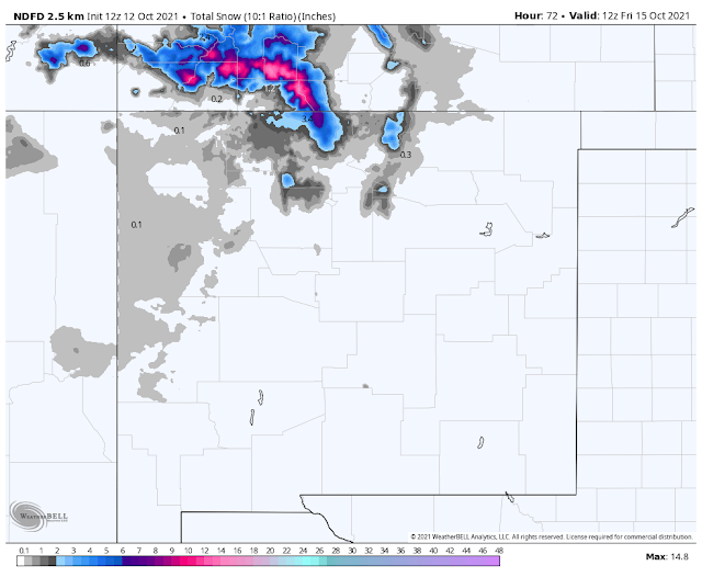
Valid Today Through 6 PM MDT Thursday.

Guadalupe Pass clocked a peak gust of 84 mph Sunday afternoon.
The Truth Is Stranger Than Fiction!


Comments
Post a Comment
Your comments, questions, and feedback on this post/web page are welcome.