Showing posts from February, 2015
NWS Albuquerque Forecasts
NWS Miscellaneous Forecasts
Why Are My Weather Posts Missing From Facebook.
Hello everyone. I just wanted to let you know that my Facebook page was shut down without any warning by Facebook this past Saturday, June 8th. All I was told was that I had violated their community standards. I don't know what triggered that; they didn't tell me. I was told this may be permanent or for six months.
My guess is that it may be because I posted several comments and articles from my Substack page about the riots in LA, and that must have triggered/angered someone, and they complained, thus Facebook shut me down. I don't know this as fact, though. I have appealed this decision, and I'm still waiting for their reply. I have read on X that this has happened to other Facebook users posting about the LA riots as well.
I always share my weather blog posts (that I post here) on my Facebook page and my X page. This included over twelve different New Mexico and West Texas Facebook Community sites. So there are thousands of you out there (based on my views and shares of those posts) who will no longer see those posts. My Facebook page may or may not be restored.
This is another good reason (as the National Weather Service often reminds us) to have multiple ways of receiving severe weather alerts when severe weather threatens your location. My weather web page is one of those ways, and I really appreciate all of you who have and still do use it. Thank you so much!!!
If my Facebook page is restored, I will continue to share my weather blog posts and some of the NWS Watches and Warnings...as I have been doing for years now.
Shared On Twitter By KRQE's Meteorologist John Smith. Courtesy Of Sam Sanborn in Albuquerque, NM. Temperatures @ 7 AM MST This Morning. Reported Low Temperatures This Morning. Modeled Snow Depths @ 9 AM MST This Morning.
Ski Apache Today. Courtesy Of The Ski Apache FaceBook Page. 4" Of Snow In Roswell, NM This Morning. Courtesy Of Chaves County Skywarn Coordinator Jim Tucker. 2 PM MST Temperatures. Socked In With Low Clouds.
No Doubt Many People Feel This Way This Winter. Long Duration Winter Storm Event For New Mexico. Click On This Link For The Latest NWS Watches & Warnings. A Winter Weather Advisory is in effect for Eddy and Lea Counties from 8 PM tonight into 11 AM Friday. Current NWS forecasts are calling for 2" - 4" of snow for us. As always we will see a varation of snowfall totals locally depending upon the exact track and speed of our inbound storm. I find it curious that Chaves County was not included in the Advisory, nor was Otero County. Courtesy Of The Albuquerque NWS Office. Arctic Air Settles In As Snow Pick Up Tonight. GFS (T1534) 500 MB Analysis. Valid @ 11 AM MST This Morning. Arctic air has settled into the eastern one half of New Mexico once again today. Low level easterly upslope flow behind the arctic cold front continues to import abundant low level moisture into the area. At the same time an upper level disturbance will dive s...
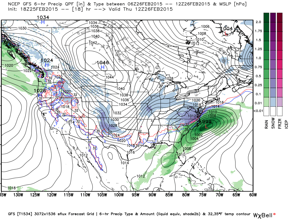
GFS Surface MSLP & Precipitation Type Forecast. Valid @ 5 AM MST Thursday. Canadian (RGEM) Snowfall Forecast. Valid @ 11 AM MST Friday. NCEP WPC Snowfall Forecast. Valid @ 5 AM MST Saturday. NCEP NDFD Snowfall Forecast. Valid @ 5 PM MST Saturday. A quick update with more details posted on Thursday. Simply put its back to winter by sunrise tomorrow morning when yet another arctic cold front enters southeastern New Mexico. Once again light snow is in our forecast starting late tonight and continuing into late Friday night. After seeing the mid 60's today in southeastern New Mexico we will only see the mid-upper 30's tomorrow and we will be lucky to break the freezing mark on Friday. A very active and stormy winter pattern will affect New Mexico tonight into next week. And to quote the Albuquerque NWS Office: "Northern New Mexico Mountainous locations may be measuring their snowfall by the feet when this is all said and done next ...
Visible Satellite Image @ 3:45 PM MST This Afternoon. GFS 500 MB Analysis @ 18Z/11 AM MST Today. RAP Temperatures @ 2 PM MST Today. Cold air (although warming up compared to yesterday) remains entrenched over the area. Meanwhile our upper level storm was centered over central Arizona today around noontime. It is forecast to move southeast into southeastern New Mexico and West Texas tonight into tomorrow morning. A cold unstable airmass aloft will accompany this storm as it moves overhead which will interact with the low level moisture already in place. This and the lift associated with the inbound storm will help to produce snow across the area tonight into tomorrow morning. The short range models vary with their thinking as far as snowfall totals are concerned but generally agree that we will see the white stuff fall from the sky tonight into tomorrow morning. It appears that snowfall totals in southeastern New Mexico will range from just t...
Courtesy Of NOAA. Great Lakes Total Ice Cover Nears 85 Percent: The NOAA Great Lakes Environmental Research Laboratory is showing total Great Lakes ice cover of 84.4 percent as of February 22, 2015, well above the long term average and closing in on last year's mark of 92.5 percent coverage on March 6, 2014. In this image, Lake Erie is a vast white plain, joining Lake Huron and Lake Superior with coverage's above 90 percent and only small areas of open water. This image was taken by the NOAA/NASA Suomi NPP satellite's VIIRS instrument around 1803Z on February 23, 2015. Download it at http://www.nnvl.noaa.gov/MediaDetail2.php… . COLD Day In New Mexico. RAP Temperatures @ 2 PM MST Today. RAP Temperature Anomalies @ 2 PM MST Today. Temperatures have changed very little so far today and little additional change from current readings is forecast into tomorrow morning. We are some 30-40 degrees below normal here in the southea...
Much Colder Today. Regional Temperatures @ 4 PM MST This Afternoon. Regional Temperatures @ 4 PM MST This Afternoon. Note the sharp temperature contrast across the eastern one half of New Mexico verses just west of the central mountain chain. Arctic air is entrenched over the eastern plains where temps at 4 PM ranged from the single digits in northeastern New Mexico to near 30 in southeastern New Mexico. Southwest New Mexico was in the low 70's. Winter Storm Is Still T Our West. Latest IR Satellite Image @ 4:15 PM MST Today. GFS 500 MB Forecast. GFS 500 MB Forecast. Valid @ 11 AM MST Tuesday. GFS Surface Precipitation Type Forecast. GFS Surface Precipitation Type Forecast. Valid @ 11 PM MST Tonight. GFS Surface Precipitation Type Forecast. Valid @ 5 AM MST Monday. GFS Surface Precipitation Type Forecast. Valid @ 11 AM MST Monday. GFS Surface Precipitation Type Forecas...