Posts

Showing posts from January, 2017

My Blog Archive List (July 2010 - August 2025).

Show more

Recent Posts

Cannon AFB (KFDX) Radar Outage

Updated 10/01/2025 11am The Cannon Air Force Base (KFDX) WSR-88D will remain inoperable for an extended period due to a hardware failure at the site. Parts have been ordered. There is currently no estimate on when the radar will return to service. KFDX radar is the only radar coverage for portions of eastern New Mexico. However, you may find KPUX, KAMA, KLBB, and KMAF radars useful. If you have questions or concerns, please contact Cannon AFB Public Affairs at 575-784-4131.

Viewing My Web Page

If you are viewing my web page on your cell phone, then be sure and click on the three white bars located in the top left-hand corner of the page (only visible on your phone). This is the menu bar, and it opens up additional links and graphics. Such as forecast maps, severe weather outlooks, current conditions, radar and satellite links, and more.

Unseasonably Warm Today!

Image
Temperatures @ 4 PM MST Today. Unseasonably Warm Today With More To Come. 

Sierra Blanca Peak - Ruidoso, NM. 1-28-2017.

Image
Ski Apache  located west of Ruidoso with a base altitude of 9,600' has received 59" of snowfall so far this season. They currently have a 61" base. Their seasonal average is 180" . Sierra Blanca Peak rises up to 12.003' and can be seen from more than 100 miles on a clear day. The Truth Is Stranger Than Fiction!

Snow Showers Obscuring The Guadalupe Mtn's.

Image
Snow showers were obscuring the Guadalupe Mountains of Southeastern New Mexico and Texas this afternoon. The last two photos above were shot in Whites City, looking south down U.S. Highway 62/180 (The El Paso Highway). The snow never made it as far north as Carlsbad.  The Truth Is Stranger Than Fiction!

Cooler Today Into The Weekend.

Image
Temperatures @ 4 AM MST. Cooler Today Into The Weekend.

Wind Machine Cranks Tonight Into Tuesday!

Image
Wondering The Folks On That Jet Had A Rough Ride...Note The Contrail Passing Through The Lenticular Cloud. January 23rd, 2017. Altocumulus Standing Lenticular Clouds South - Southeast Of Carlsbad, NM. Wind Machine Cranks Up Tonight & Howls Again Tuesday.

NM Storm Total Snowfall Amounts & NM & W TX Peak Wind Gusts.

Image
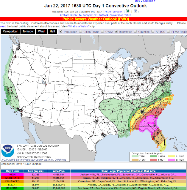
Today's Severe Weather Outlook. Public Severe Weather Outlook.  Numerous Tornadoes today, several of which will be of the intense, long track nature in the areas highlighted in pink and red on the map above!.  Yesterday Was Windy - Tuesday Will be Windy Once More!

Significant High Wind Event Today - Heavy Snow In the Sac's.

Image
Blog Updated @ 10:09 AM MST. Blog Updated @ 1:35 PM MST. 1-19-2017. Altocumulus Standing Lenticular Clouds 30 Miles South Of Carlsbad, NM. Significant High Wind Event Today!

NM Storm Total Rainfall/Snowfall Amounts.

Image
Ski Apache This Afternoon. Cloudcroft This Afternoon. Ski Cloudcroft Picked Up 10" From This Latest Storm. Widespread Moderate To Heavy Rainfall & Snowfall.

NM WX Past 24 Hrs - SVR T-Storms-Hail/Heavy Rain-Localized Flooding/Freezing Rain-Sleet/Heavy Mtn Snow/Dense Fog

Image
Blog Updated @ 4:25 PM MST. NWS Watches & Warnings In Effect. (Click On This Link For The Latest Info). Severe T-Storms - Heavy Rains - Heavy Mountain Snows Today!

Severe T-Storms - Heavy Rain - Heavy Mtn Snows To Hammer NM.

Image
RAP 500 MB Analysis @ 8 AM MST This Morning. Complicated & Very Strong Winter Storm To Hammer New Mexico!

Weekend Winter Storm Headed To NM.

Image
January 11, 2017. (CCSL) Cirocumulus Standing Lenticular Clouds. Southwest Of Carlsbad Over The Guadalupe Mtn's.  Next Major Winter Storm Impacts NM Friday - Sunday.

Very Warm Day Across SE NM & W TX.

Image
Temperatures @ 4 PM MST This Afternoon. NWS MesoWest Reported High Temperatures Today. High Temp Today @ Our Home In Carlsbad, NM. The Carlsbad Airport recorded a high temperature of 81ºF this afternoon. This should be a record for the date surpassing the previous high of 78ºF set in 2002. The record high temperature for the Carlsbad Climate Station is 84ºF set in 1909. The Roswell Airport  recorded a high this afternoon of 81ºF and this should tie the old record of 81ºF set back in 1909.  The Truth Is Stranger Than Fiction!

80-Degrees On Monday - Freezing Rain, Sleet, Snow By Friday?

Image
U.S. Surface Map. Valid @ 11 AM MST This Morning. 80-Degrees On Monday - Back To Winter Friday!

Coldest Morning Of The Winter For Most Of SE NM.

Image
RAP Regional Temperatures. Valid @7 AM MST This Morning. Blog Updated @ 3:25 PM MST. Coldest Morning Of The Winter For Most-

Major Winter Storm Underway In New Mexico!

Image
Regional Radar Snapshot @ 5:47 PM MST This Evening. Major Winter Storm Underway In New Mexico-  Winter Storm Warnings! Winter Weather Advisories!

Dangerous Winter Storm Taking Aim At New Mexico!

Image
Altocumulus Standing Lenticular Clouds. (East & Southeast Of The Guadalupe Mtn's). Powerful Winter Storm To Hammer NM Thursday Into Friday.

Severe Thunderstorms Of All Things New Years Evening! - Next Arctic Invasion Wednesday Night?

Image
January 2nd, 2017. Altocumulus Standing Lenticular Clouds Southwest Of Carlsbad. NM.

Heavy Snow For The Sac's & T-Storms For SE NM Tonight!

Image
Happy New Year Everyone!!! Apache Ski @ 2;30 PM MST Today. As of Noontime today the Sierra Blanca Snotel (Automated Weather Station) located near Ski Apache, west of Ruidoso, had picked up 3" of new snow. 

Current US Hazardous Weather Watch/Warning Map

New Mexico

Eddy County

Guadalupe Mtns Eddy & Culberson County

Chaves County Plains & Mtn's

Lea County

Lincoln County

Otero County

Pagosa Springs, Colorado Flooding Oct 12, 2025

Arizona Flooding - Oct 12, 2025

🔴 Live 24/7 National Weather Radar & Alerts, Weather Intensity Score & YallBot!

Ruidoso Live Webcam

Ski Apache Webcam Live Link

Ski Apache Webcam Live Link
Click On The Image To Open It Up

Cloudcroft Live Webcam

Roswell Live EarthCam

New Mexico Weather Tweets

Average Daily High/Low Temperatures & Rainfall/Snowfall

My Rainfall Totals. 2.1 NNW Downtown Carlsbad, NM.

Popular posts from this blog

Artesia, NM Mothership Supercell Thunderstorm. 9-17-2016.

Monster Of A Snowstorm Coming This Christmas Weekend?

Powerful Winter Storm Is Hammering New Mexico! Worst Is Yet To Come.

25th Anniversary Of The Carlsbad, NM (May 31, 1991) Tornado Coming Up.

Major Winter Storm May Paralyze/Bury Parts Of NM & Nearby Areas Tonight Into Wednesday!

2011 Skywarn Spotter Training Classes & My Thoughts.

Tonight's GFS Is As Drunk As This Mornings ECMWF. Historic Snowstorm Next Weekend?

Are We Fixing To Go From Drought To Flood In SE NM?

Major Winter Storm To Hammer New Mexico & West Texas Thanksgiving Week!

Cloudcroft & Ruidoso, NM Seasonal Snowfall Totals.

My Favorite Blog List.

Substack

Disclaimer

This blog and its contents are for informational purposes only! Always have multiple sources of information available to rely upon during severe weather. Do not rely solely on the Internet. Be weather-aware, plan ahead, have a backup plan, and be ready to act before severe weather strikes your location.