Posts

Showing posts from August, 2018

Saturday Ushers In The Beginning Of The Meteorological Fall With Goods News.

Image
August 30th, 2018. Argo/Hidalgo Gas Plant 21 Miles West Of Orla, Texas. Summer Upper Air Pattern Fades As The Meteorological Fall Arrives. ECMWF 500 MB (18,000' MSL) Forecast. Valid At 6 PM MDT Saturday, September 1st, 2018. Valid At 6 AM MDT Tuesday, September 4, 2018. Our summer heat ridge (at the mid levels of the atmosphere or the 18,000' level) has shifted east to eastern third of the nation today. Meanwhile a trough of low pressure is digging southward from south-central Canada into the Desert Southwest. This mid-level trough is forecast to stick around through the first of next week. This will help knock our temps down and increase our chances for rain from tomorrow into the at least the middle of next week. Subtropical moisture from Mexico is forecast to spread northward into New Mexico during this time. Week Long Rains Forecast? ECMWF Forecast Storm Total Rainfall Amounts. Valid Today Through Next Thursday Morning. GFS Fo

Test Drive Of My New Nikon D5600 Camera.

Image
Thunderstorm Outflow Winds Kick Up Blowing Dust At Lakewood.  Mist Trails From A Passing Vehicle.   Even Though Its Rained Its Not Enough - Keep Those Irrigation Sprinklers Going Day And Night On The Cotton Fields.  Rained On Alfalfa. Raked And Almost Ready To Bail. While Rain Threatens In The Background At Least This Cutting Of Alfalfa Got Bailed Up Green. Now To Haul It To The Barn Before It Gets Rained On. Thunderstorms once again popped up across Southeastern New Mexico this afternoon. So my wife and I took off towards Artesia to try out my new Nikon D5600 camera. My early Christmas present from my beautiful wife...I've waited years for a Nikon. I've a lot to learn about this camera and that was quickly realized. Overall although I'm somewhat overwhelmed with its many functions I'm extremely pleased with it. Now to work on my manual raw shots verses jpeg auto shots. Let the fun begin! The Truth Is Stranger Than Fiction!

Hit & Miss T-Storms Saturday - Rainfall Observers Needed Please Join CoCoRaHS.

Image
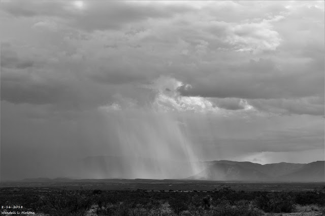
August 18th, 2018. Near Hondo, New Mexico. One of the reasons that we've seen so much variability in our summer rainfall this year is because of the nature of our thunderstorms. Hit and miss type storms like the one pictured above have been the norm. Notice that this rain shaft was perhaps 1/4 of a mile wide. So whoever was underneath it likely got a decent amount of rain but everyone else surrounding it got left out. Roswell Was A Good Example Yesterday. GRLevel3 CoCoRaHS 24-Hour Rainfall Totals. As Of 8 AM MDT Sunday, August 26th, 2018. Combination Of 24-Hour Reported & Radar Estimated Rainfall Totals. (As Of 8 AM MDT Sunday, August 26th, 2018). August 25th, 2018. South Of Roswell, New Mexico Looking Back To The Northwest. Thunderstorms formed west through north of Roswell Sunday afternoon before eventually moving off to the northeast. We were about 15 miles south of town when I took the photo above. Radar estimated that 2" of

Last Nights Rainfall Totals.

Image
Saturday, August 18, 2018. What looked like a small and very brief shear funnel cloud that lasted less than one minute popped out of the base of this thunderstorm east of Ruidoso Downs this past Saturday morning at 11:41 AM MDT. Its just above the hilltop and to the left of the flag pole.  Last Nights Rainfall. Radar Estimates & Reported 24-Hour Totals. (As Of 4 PM MDT This Monday Afternoon). Judging by the intense lightning generated by this mornings complex of thunderstorms (MCS) that rolled southward through the Pecos Valley and the Caprock area you would have thought that most of us got clobbered by heavy rain. Not so. Once again it was a true case of hit and miss. There were pockets of 1" to 2" totals but these occurred east of Artesia and Carlsbad, and south and southwest of Carlsbad. Midland NWS Doppler Radar Estimated 24-Hour Rainfall Totals. Rainfall estimates by the Midland National Weather Service

Crepuscular Rays Over The Guadalupe's.

Image
8-16-2018. 8-16-2018. Crepuscular Rays - Same photo - same place...different views...black & white verses color. Looking west at the Guadalupe Mountains from Farm Market Road #652 just south of the New Mexico/Texas State Line southwest of Carlsbad, New Mexico. The Truth Is Stranger Than Fiction!

A Cool Morning - A Reprieve From Our Hot Summer Nights.

Image
RTMA Temperatures. At 6 AM MDT Monday, August 13, 2018. Reported Low Temps This Morning. (Monday, August 13, 2018). Local reported low temperatures (a combination of official and non official readings) were noticeably cooler this morning. The 40's were widespread across the Sacramento Mountains, with the 50's reported in the Guadalupe's. While most of the southeastern plains were in the 60's. Roswell officially dropped down to 61º for a low this morning making this their coolest morning since June 18th...also a low of 61º. Artesia officially dropped down to 61º for a low this morning making this their coolest morning since July 1st when they reported 59º.  Carlsbad officially dropped down to 63º at the airport which ties the 63º on August 6th. Prior to these dates the last time this summer that the Carlsbad Airport was this cool was back on June 4th with a low of 61º.  This Mornings Lows Hint At Fall Down The Road Although

Current Watches In Effect

Storm Prediction Center (SPC) Day 1 Severe Weather Outlook

SPC Mesoscale Discussions

Current NWS National Watches/Warnings In Effect

Current NWS National Watches/Warnings In Effect
Click On The Map For The Latest Updates

New Mexico

NWS Regional Radar

NWS Regional Radar

GOES-East - Sector view: Southern Rockies - GEOColor

Current US Temps

Current US Wind Chill/Heat Index Temperatures

NWS Midland Radar

NWS Midland Regional Forecast

NWS Midland Regional Forecast

NWS Midland Regional Forecast

Cannon AFB Radar

NWS Albuquerque Radar

NWS Albuquerque Regional Forecast

NWS Albuquerque Regional Forecast

NWS Albuquerque Regional Forecast

NWS Albuquerque Regional Forecast

Holloman AFB Radar

NWS El Paso Radar

NWS El Paso Regional Forecast

NWS Lubbock Radar

NWS Lubbock Regional Forecast.

NWS Lubbock Regional Forecast

NWS Lubbock Regional Forecasts

NWS Lubbock Regional Forecast

NWS Forecast High Temps Today

NWS Forecast Low Temps Tonight

24-Hour Minimum Wind Chill Forecast

NWS Albuquerque Storm Total Snowfall Forecast

NWS Albuquerque Storm Total Rainfall Forecast

NWS Midland Storm Total Rainfall Forecast

NWS El Paso Storm Total Rainfall Forecast

Average Daily High/Low Temperatures & Rainfall

Average Daily High/Low Temperatures & Rainfall