Posts

Showing posts from August, 2019

Drought & Heat This Summer - No Relief In Sight.

Image
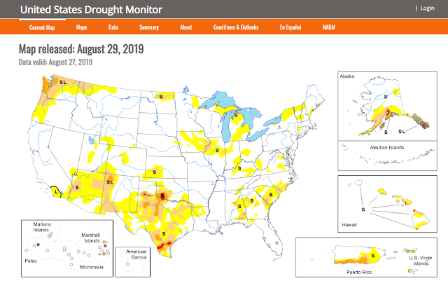
Abnormally dry conditions persists across much of the local area. If you are thinking its been a hot and dry summer you are correct. Long range forecast models don't offer much long term hope of relief at this point in time either. If they are to believed our developing drought will slowly worsen in some areas with time as we head into fall.  Radar Estimated & Reported August 2019 Rainfall. August 2019 Rainfall Anomalies. These rainfall graphic maps are misleading in my opinion. There have been pockets of heavy rainfall this month but comparing these maps with the reported totals noted below it appears that the radar estimates have been too high. Local Rainfall Totals. (August 2019). Southeastern Plains. South-Central Mountains. Southern New Mexico Year-To-Date Radar Estimated & Reported Rainfall Totals. (January 1st - August 30th, 2019). These year-to-date rainfall graphic maps are

New Daily/Monthly Record High Temps For August 2019.

Image
Reported High Temps. Monday, August 26, 2019. New Daily NWS Record High Temperatures. (Monday, August 26, 2019). New August Record High Temps. The Truth Is Stranger Than Fiction - And Sometimes It Hurts!

Wednesday Afternoon & Wednesday Nights Local Rainfall Totals.

Image
El Paso NWS Dual Pol Doppler Radar  Estimated Rainfall Totals Wednesday Afternoon. Holloman AFB Dual Pol Doppler Radar  Estimated Rainfall Totals Wednesday Afternoon. Tularosa Basin Rainfall Totals. Wednesday Afternoon. Pecos Valley Rainfall. Wednesday Night. CoCoRaHS Rainfall Totals. In The Northern Sacramento Mountains Wednesday Night. CoCoRaHS Rainfall Totals. In The Pecos Valley Wednesday Night. Weather Underground Rainfall Totals Wednesday Afternoon. Rainfall Totals From Wednesday Night. True to this summers theme rainfall-wise hit and miss thunderstorms Wednesday afternoon dumped 2" to 3" of rain in and close to the Alamogordo area. A CoCoRaHS rainfall observer measured 2.20" in Alamogordo. Wednesday night saw a complex of thunderstorms roll southward through the Pecos Valley dropping .10" to .60" in and around the Artesia and Atoka areas, and around .50" to 1.80&q

A Brief Break Wednesday & Thursday.

Image
8-11-2019. High Based T-Storms Southwest Of Hope. Wide swatches of the local area remain parched and burnt from the lack of rain and heat. NAM 3K Forecast High Temps. Today. Wednesday. NAM 3K Composite Radar Forecast. Valid At 5 PM Wednesday Afternoon. NAM Storm Total Rainfall Forecast. Valid At 6 AM MDT Thursday. So far this summer I've reached 100º or higher on 31 days here at our home in northwest Carlsbad. Forecast highs today in the Pecos Valley will average around 99º to 103º. A couple of the forecast models offer some brief relief from the heat late Wednesday afternoon into Thursday night. A complex of thunderstorms (MCS) is forecast to move southward down the plains and into the Pecos Valley late Wednesday. Locally heavy rainfall will be possible with a the stronger storms possibly producing rainfall totals of around 1" to 2".  Notice that the NAM forecast model (depicted above) shows this complex of thun

Current Watches In Effect

Storm Prediction Center (SPC) Day 1 Severe Weather Outlook

SPC Mesoscale Discussions

Current NWS National Watches/Warnings In Effect

Current NWS National Watches/Warnings In Effect
Click On The Map For The Latest Updates

New Mexico

NWS Regional Radar

NWS Regional Radar

GOES-East - Sector view: Southern Rockies - GEOColor

Current US Temps

Current US Wind Chill/Heat Index Temperatures

NWS Midland Radar

NWS Midland Regional Forecast

NWS Midland Regional Forecast

NWS Midland Regional Forecast

Cannon AFB Radar

NWS Albuquerque Radar

NWS Albuquerque Regional Forecast

NWS Albuquerque Regional Forecast

NWS Albuquerque Regional Forecast

NWS Albuquerque Regional Forecast

Holloman AFB Radar

NWS El Paso Radar

NWS El Paso Regional Forecast

NWS Lubbock Radar

NWS Lubbock Regional Forecast.

NWS Lubbock Regional Forecast

NWS Lubbock Regional Forecasts

NWS Lubbock Regional Forecast

NWS Forecast High Temps Today

NWS Forecast Low Temps Tonight

24-Hour Minimum Wind Chill Forecast

NWS Albuquerque Storm Total Snowfall Forecast

NWS Albuquerque Storm Total Rainfall Forecast

NWS Midland Storm Total Rainfall Forecast

NWS El Paso Storm Total Rainfall Forecast

Average Daily High/Low Temperatures & Rainfall

Average Daily High/Low Temperatures & Rainfall