


Easter Snowstorm & Freeze?


Spring is a time of change and that often means wild weather swings across the U.S. Winter is in its lasts gasps of trying to hang on as the sun slowly climbs higher in the sky and lingers longer each day. It is absolutely beautiful across the Land of Enchantment this afternoon with light winds for the most part and temperatures in the 80's here in Southeastern New Mexico and parts of West Texas. Enjoy it while it lasts because some wild changes are ahead this Easter weekend into the first of next week.
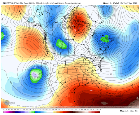
Strong Storm Heads Our Way This Easter Weekend.
Valid At 6 AM MDT This Tuesday Morning.
A strong mid-level closed low is located west of central California today. This storm will more or less wobble around that area into the beginning of the holiday weekend before beginning to drop southeastward into northern Mexico.
ECMWF 500 MB/18,000' Forecast.

Valid At 6 AM MDT This Coming Saturday.

Valid At 6 AM MDT Thursday Morning.
Wednesday.

Thursday.

Wednesday's forecast high temperatures locally will be close to today's perhaps a few degrees warmer. Thursday a Pacific cold front will be approaching from the west while modified cold front backdoors into the area from the north and east. After seeing a couple of days with highs in the 80's we are forecast to drop down into the 70's. Highs will range in the 70's through the Easter holiday weekend. Then the bottom potentially falls out Monday.
Will Winter Take A Cheap Shot At Us Monday?

Valid At Noon MDT.
ECMWF Forecast Temperature Anomalies.

Valid At Noon MDT Monday.
ECMWF Surface Map Forecast.

Valid At 6 AM MDT Monday.
ECMWF Snowfall Forecast.

Valid At 6 PM MDT Monday, April 13th, 2020.
First and foremost it is simply way too early to get too excited about what the various global forecast models are coming up with for early next week. But there is a pretty strong signal that winter may not be done with us. How cold, will it snow, if so how much? These questions come to mind but I simply can't answer them with any degree of certainty yet. Colder weather with the possibility of a freeze is in the cards. Snow could also be possible in some areas of the state. More later as the models settle down and try and resolve this.
The Truth Is Stranger Than Fiction!


Comments
Post a Comment
Your comments, questions, and feedback on this post/web page are welcome.