Posts

Showing posts from October, 2021

Yesterday's Peak Wind Gusts - Winter Next Week?

Image
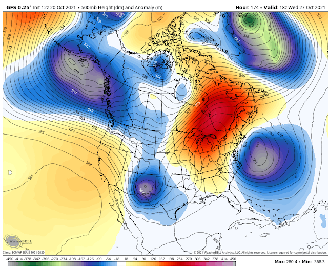
October 24, 2021. Cloudcroft, New Mexico. NWS MesoWest Reported Wind Gusts Tuesday. New Mexico & W Tx Reported Peak Wind Gusts. ECMWF Forecast High Temperatures. Next Wednesday. Next Thursday. Next Friday. ECMWF Snowfall Total Forecast. Next Weeks Winter Weather? A potential winter storm (our first for the season) is in the cards from the middle to the end of next week. Computer model forecasts indicate that a strong closed mid-upper level low may develop over the central plains of the U.S. next week. If so then this may send our first backdoor arctic cold front into the local area. Last night's European forecast model (ECMWF) forecasts light snow locally by the end of next week. You know the drill...it's way too early to get overly excited about this since we are a week to ten days away from the event. More on this later. The Truth Is Stranger Than Fiction!

Windy & Dusty Today - Cooler The Rest Of The Week.

Image
October 24, 2021. Near Elk, New Mexico. GFS 500 MB (18,000') MSL Analysis/Forecast. Valid At Midnight MDT Monday Night. Valid At Midnight MDT Tonight. Our long-awaited storm will move southeastward out of Nevada today and by midnight it will be centered across northeastern New Mexico and southeastern Colorado. This northern track will make this storm a wind maker locally with little chance for precipitation.  Surface Map Analysis/Forecast. Analysis Valid At 3 AM MDT Tuesday Morning. Forecast Valid At 6 PM MDT Tuesday Evening. NWS NDFD Storm Total Rainfall & Snowfall Forecasts. (Today - Wednesday). NWS NDFD Forecast High Temperatures. Today. Wednesday. Thursday. Friday. NWS NDFD Forecast Low Temperatures. Thursday Morning. Friday Morning. Windy & Dusty Today. High Wind Warnings are in effect today for Eddy County, the Guadalupe Mountains, southwest Chaves County, Lincoln County, and Culberson County in West Texas. Wind Advisories are in effect today for the rest of the loca

Near Record Heat Monday - Windy Tuesday.

Image
October 18, 20-21. Carlsbad, New Mexico.  Cirrocumulus   is one of the three main genus-types of high-altitude tropospheric  clouds , the other two being  cirrus  and  cirrostratus . [3]  They usually occur at an altitude of 5 to 12 km (16,000 to 39,000 ft). Like lower-altitude cumuliform and stratocumuliform clouds, cirrocumulus signifies  convection . Unlike other high-altitude tropospheric clouds like cirrus and cirrostratus, cirrocumulus includes a small amount of liquid water droplets, although these are in a  supercooled  state. Ice crystals are the predominant component, and typically, the ice crystals cause the supercooled water drops in the cloud to rapidly freeze, transforming the cirrocumulus into cirrostratus. This process can also produce precipitation in the form of a  virga  consisting of ice or snow. Thus, cirrocumulus clouds are usually short-lived. [4]  They usually only form as part of a short-lived transitional phase within an area of cirrus clouds and can also form

Next Potential Storm To Impact The Region Next Week.

Image
First Look At Next Weeks Storm. GFS 500 Millibar (18,000') Forecast. Valid At Noon MDT Wednesday, Oct 27, 2021. ECMWF  500 Millibar (18,000') Forecast. Valid At Noon MDT Wednesday, Oct 27, 2021. GEM  500 Millibar (18,000') Forecast. Valid At Noon MDT Wednesday, Oct 27, 2021. Our local weather of late has been rather tranquil of late. Our temperatures have been running a little above average to date but other than that nothing significant has occurred recently. Parts of the local area did receive their first freeze of the season. Freezing temperatures have occurred across the Capitan and Sacramento mountains generally above 6,000'. The area has yet to experience its first widespread killing freeze at the lower elevations of the Southeastern Plains  Listed below are the locations and their reported freezing temperatures and dates of occurrence. A very active jet stream will continue to send very strong mid-upper level storms into the Gulf of Alaska today into the first o

Current Watches In Effect

Storm Prediction Center (SPC) Day 1 Severe Weather Outlook

SPC Mesoscale Discussions

Current NWS National Watches/Warnings In Effect

Current NWS National Watches/Warnings In Effect
Click On The Map For The Latest Updates

New Mexico

NWS Regional Radar

NWS Regional Radar

GOES-East - Sector view: Southern Rockies - GEOColor

Current US Temps

Current US Wind Chill/Heat Index Temperatures

NWS Midland Radar

NWS Midland Regional Forecast

NWS Midland Regional Forecast

NWS Midland Regional Forecast

Cannon AFB Radar

NWS Albuquerque Radar

NWS Albuquerque Regional Forecast

NWS Albuquerque Regional Forecast

NWS Albuquerque Regional Forecast

NWS Albuquerque Regional Forecast

Holloman AFB Radar

NWS El Paso Radar

NWS El Paso Regional Forecast

NWS Lubbock Radar

NWS Lubbock Regional Forecast.

NWS Lubbock Regional Forecast

NWS Lubbock Regional Forecasts

NWS Lubbock Regional Forecast

NWS Forecast High Temps Today

NWS Forecast Low Temps Tonight

24-Hour Minimum Wind Chill Forecast

NWS Albuquerque Storm Total Snowfall Forecast

NWS Albuquerque Storm Total Rainfall Forecast

NWS Midland Storm Total Rainfall Forecast

NWS El Paso Storm Total Rainfall Forecast

Average Daily High/Low Temperatures & Rainfall

Average Daily High/Low Temperatures & Rainfall