Winter Storm #2 Taking Aim On SE NM.
Winter Storm #2 which was located just west of the northern California Coast (circled in red in the Water Vapor Satellite image above, and black on the NAM model image) this morning.
NAM 500 MB Forecast Valid At 5 AM MST Sunday.
NAM 500 MB Forecast Valid At 5 AM MST Monday.
NAM 500 MB Forecast Valid At 5 AM MST Tuesday.
NAM 500 MB Forecast Valid At 5 PM MST Tuesday.
This Mornings 12Z/5 AM MST GFS 500 MB Forecast.
Valid At 5 PM MST Tuesday January 8, 2013.
Last Nights ECMWF 500 MB Forecast.
Valid At 5 PM MST Tuesday. January 8, 2013.
Comparing last nights European model (ECMWF) with this mornings NAM and GFS model forecasts its easy to see that they are fairly close in their forecasts as far as the track of the storm is concerned.
The European and GFS models are tracking the storm a little further to the south, which is important because it also brings colder air further south into the area, thus a better chance of seeing snow. Just how much cold air will be in place is a little uncertain at this point...as is the amount of moisture this storm have to work with.
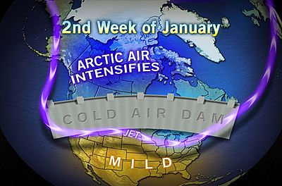
Bitterly Cold Arctic Invasion Starting Mid-January?
"Much of the nation has been experiencing higher-than-average
temperatures and lower heating bills so far during the cold weather
season, with the exception of some bouts the past couple of weeks.
However, there are signs of a potential change on the way beginning during the second half of January.
A phenomenon known as sudden stratospheric warming has occurred in
the arctic region during the past few days. The stratosphere is located
between 6 miles and 30 miles above the ground.
Often when this occurs, it forces cold air to build in the lowest layer of the atmosphere then to drive southward."
REX Block Opens Up The North Pole Front Door.
500 MB REX Block Forecast To Setup By Around Jan 11th.
High Pressure Over The Pacific & Atlantic Sends Polar Air South.
GFS Surface Temp & Temp Anomaly Forecasts.
Valid 5 PM MST Tuesday January 14, 2013
Talk about an invasion from the North Pole! First of several of these outbreaks.
The Truth Is Stranger Than Fiction!
My Web Page Is Best Viewed With Google Chrome.


Comments
Post a Comment
Your comments, questions, and feedback on this post/web page are welcome.