My Blog Archive List (July 2010 - August 2025).

Show more

About

Viewing My Web Page

If you are viewing my web page on your cell phone, then be sure and click on the three white bars located in the top left-hand corner of the page (only visible on your phone). This is the menu bar, and it opens up additional links and graphics. Such as forecast maps, severe weather outlooks, current conditions, radar and satellite links, and more.

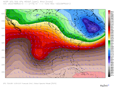
Snow For The First Week Of April - Say What?


Vaqlid @ 6 AM MDT Wednesday April 3, 2013.

GFS Max Temperature Anomaly Forecast.
Valid @ 6 PM MDT Tuesday, April 2, 2013.

So you thought winter was over hum? Well maybe not...

GFS Surface Forecast.
Valid @ 6 AM MDT Wednesday, April 3, 2013.

GFS Total 6-Hourly Snowfall Accumulations.
Valid @ Midnight Wednesday, April 3, 2013.


Albuquerque, NM.

Carlsbad, NM.

Ruidoso, NM.

Ridiculous forecasts for the first week of April I agree, but not unheard of. On April 6, 1983 Artesia, New Mexico recorded 7" of snow on the ground and I measured 9" in Lakewood. Time will tell if last nights run of the GFS model is pure fantasy or reality.

The Truth Is Stranger Than Fiction! 

My Web Page Is Best Viewed With Google Chrome.

Comments

  1. Originally from Denver, I figured you were talking about the western great plains, but further north. That's a bullseye on Lubbock! And Abq gets in on it! (maybe it will stay east of the mountains this far out?)

    ReplyDelete
  2. The 7" in Artesia and your 9" snow are amazing, and probably a similar set-up? Those maps imply an upslope flow setting up behind a polar front. I always hear about the 12"+ snows during 2 different Aprils by native El Pasoans...looking for online photos of that.

    ReplyDelete
  3. That was one amazing spring storm, not soon to be forgotten either. A heavy wet snow fell over a broad swath of southern NM & W TX.

    I have heard similar stories about the Northeast Heights of El Paso getting 18" to 24" out of that storm. If memory serves me correctly the airport picked up about 16" from that storm.

    Would love to see your photos if you come across some of them.

    ReplyDelete

Post a Comment

Your comments, questions, and feedback on this post/web page are welcome.

Current US Hazardous Weather Watch/Warning Map

New Mexico

Eddy County

Guadalupe Mtns Eddy & Culberson County

Chaves County Plains & Mtn's

Lea County

Lincoln County

Otero County

Pagosa Springs, Colorado Flooding Oct 12, 2025

Arizona Flooding - Oct 12, 2025

🔴 Live 24/7 National Weather Radar & Alerts, Weather Intensity Score & YallBot!

Ruidoso Live Webcam

Ski Apache Webcam Live Link

Ski Apache Webcam Live Link
Click On The Image To Open It Up

Cloudcroft Live Webcam

Roswell Live EarthCam

New Mexico Weather Tweets

Average Daily High/Low Temperatures & Rainfall/Snowfall

My Rainfall Totals. 2.1 NNW Downtown Carlsbad, NM.

My Top 10 Most Popular Posts

Artesia, NM Mothership Supercell Thunderstorm. 9-17-2016.

Monster Of A Snowstorm Coming This Christmas Weekend?

Powerful Winter Storm Is Hammering New Mexico! Worst Is Yet To Come.

25th Anniversary Of The Carlsbad, NM (May 31, 1991) Tornado Coming Up.

Major Winter Storm May Paralyze/Bury Parts Of NM & Nearby Areas Tonight Into Wednesday!

2011 Skywarn Spotter Training Classes & My Thoughts.

Tonight's GFS Is As Drunk As This Mornings ECMWF. Historic Snowstorm Next Weekend?

Are We Fixing To Go From Drought To Flood In SE NM?

Major Winter Storm To Hammer New Mexico & West Texas Thanksgiving Week!

Cloudcroft & Ruidoso, NM Seasonal Snowfall Totals.

My Favorite Blog List.

Substack

Disclaimer

This blog and its contents are for informational purposes only! Always have multiple sources of information available to rely upon during severe weather. Do not rely solely on the Internet. Be weather-aware, plan ahead, have a backup plan, and be ready to act before severe weather strikes your location.