Posts

Showing posts from February, 2021

Current Date & Time

February 12-19, 2021 Historic Winter Storm Summary #2.
Image
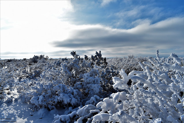
February 15, 2021. Frozen Landscape Southwest Of Whites City. Once In A Lifetime Storm For Texas? Although this sounds a bit extreme I may not be far off with this statement. The jury is still out on the final verdict...it may take some time for all of the data to be gathered and summarized. Nevertheless this event no doubt was historic, especially for Texas. Not so much for New Mexico. A lot of comparisons to the brutal February 1899 arctic outbreak have been made. Review Of The Brutal Cold Of February 1899. Let's look back in time at the coldest most widespread winter event in U.S. history (not including our current February outbreak).  THE “GREAT ARCTIC OUTBREAK OF FEBRUARY 1899” — POLAR VORTEX AND LOW SOLAR ACTIVITY TO BLAME. The “Great Arctic Outbreak of February 1899” as it became known, is one of the most widespread North American cold snaps in recorded history. It was described in a  1988 academic article  as “a benchmark with which to c ompare similar events.” Te...

Junk Grade Models: Even Short-Term Climate And Weather Modelers Get It All Wrong!

Image
Junk Grade Models: Even Short-Term Climate And Weather Modelers Get It All Wrong ! Many climate policies are based on scenarios generated by models. Depending on what these models churn out, actions and costly regulations get enacted to mitigate the worst consequences. So we hope that the modelers get it right. Unfortunately, they are still shooting in the dark. Even short-term models are failing miserably. TWC  forecast a basket case. It turns out most models are junk grade when it comes to forecast quality. For example,  The Weather Channel here not long ago issued  it’s winter outlook up through March: The area of the US now being hit by one of the most vicious cold waves in the last 100 years was indeed forecast to be “way above normal” or “much above normal”. So far the exact opposite has happened. They never saw it coming. We have to wonder what it takes to be issued a license to practice weather forecasting nowadays, and we have to feel sorry for those businesses a...

February 12-19, 2021 Historic Winter Storm Summary #1.

Image
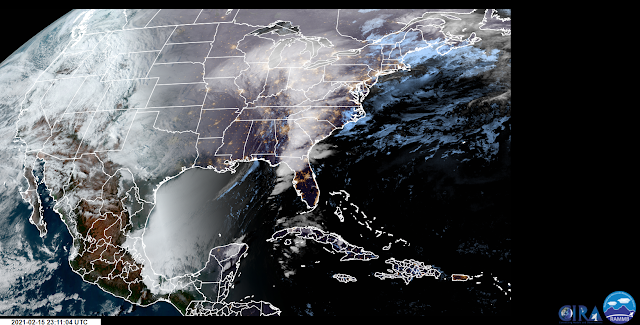
4:04 AM MST. Monday, Feb15, 2021. Geo Color Satellite Image. RTMA Temperatures. (4 AM MST Monday, Feb 15, 2021). Brutal Cold Plunges Into The Gulf Of Mexico. Take a close look at the Geo Color Satellite image at the top of the page. Notice that status clouds had covered nearly the entire Gulf of Mexico as the brutal polar airmass plunged deep into the Gulf. Temperatures at 4 AM MST had fallen below freezing with apparent temperatures down into the upper teens! I would have loved to have been aboard a commercial airliner flying over this cloud deck at 35,000' and looking down on it. That would have been a beautiful sight to behold for sure.  This Weeklong Event Was Historic.  It is going to take awhile for all of the records that were smashed by this historic long-duration polar outbreak to be complied. Widespread record cold sent the region into the deep freeze for more than a week in many nearby areas. Although most locations in Texas did not break the " Coldest Night In Texa...

My Blog Archive List (July 2010 - August 2025).

Show more

My Current Weather Conditions

MY CoCoRaHS Precipitation Data

NWS Albuquerque 2026 Winter Outlook (Updated Nov 3rd).

NWS Midland Web Page

NWS Midland Web Page
Click On The Map To Open It Up

SE New Mexico & West Texas Precipitation Forecasts

Eddy County

Guadalupe Mtns Eddy & Culberson County

Lea County

NWS Midland Hazardous Weather Outlook

NWS Midland Hazardous Weather Outlook
Click On The Image To See The Rest Of The Outlooks

NWS Midland Hazardous Weather Outlook

NWS Midland Forecast High Temperatures Today

NWS Midland Forecast Low Temperatures Tonight

NWS Midland Peak Wind Gust Forecast

NWS Midland Graphic Forecast

NWS Midland Graphic Forecast
A scheduled, nationwide test of the Emergency Alert System is planned for November 17, 2026 at 2:20 pm ET. The test message will be distributed to the public via television and radio broadcasts - NOAA Weather Radios will not receive the test. If for any reason the test cannot proceed on the assigned date, December 3 will serve as the back-up. For more information please see this Press Release (https://www.fema.gov/press-release/20261116/fema-and-fcc-conduct-nationwide-test-emergency-alert-system-november-17-2026).

NWS Midland Forecast Graphic

NWS Midland Forecast Graphic
Another cool day expected with patchy morning fog and drizzle. Clouds may try to break over some places late, but may hold over southeast New Mexico. Another chilly night tonight with patchy fog developing again in places.

NWS Albuquerque Web Page

NWS Albuquerque Web Page
Click On The Map To Open It Up

NWS Albuquerque New Mexico Precipitation Forecasts

New Mexico

Chaves County Plains & Mtn's

Lincoln County

NWS Albuquerque Hazardous Weather Outlook

NWS Albuquerque Hazardous Weather Outlook

NWS Albuquerque Forecast High Temperatures Today

NWS Albuquerque Forecast Low Temperatures Tonight

NWS Albuquerque Wind Chill Forecast

NWS Albuquerque Peak Wind Gust Forecast

NWS Albuquerque Graphic Forecast

NWS Albuquerque Graphic Forecast
A Dense Fog Advisory is in effect through 11AM MST for much of central NM, including the Santa Fe Metro.

NWS Albuquerque Graphic Forecast

NWS Albuquerque Graphic Forecast
Another round of high mountain snow accumulations are expected Tuesday night across northern NM. Between 1 and 4 inches of snow is likely. Around 6" would be a reasonable high-end snow fall amounts. Snow will taper off by noon Wednesday.

NWS Albuquerque Graphic Forecast

NWS Albuquerque Graphic Forecast
Increasing south to southwest winds are expected across parts of northern and central NM today ahead of an approaching storm system. Expect difficult crosswinds on east to west oriented roadways. Unsecured objects may blow around.

NWS Albuquerque Forecast Grpahics

NWS Albuquerque Forecast Grpahics
A storm system will bring rain and mountain snow to the area today. Chances are trending up for early next week. Temperatures will remain near to below normal this week.

NWS El Paso Web Page

Southern New Mexico & Far West Texas Precipitation Forecasts

Texas

Otero County

NWS El Paso Hazardous Weather Outlook

NWS El Paso Hazardous Weather Outlook
Click On The Image To See The Rest Of The Outlooks

NWS El Paso Hazardous Weather Outlook

NWS El Paso Hazardous Weather Outlook
Click On The Image To See The Rest Of The Outlooks

NWS El Paso Forecast High Temperatures Today

NWS El Paso Forecast Low Temperatures Tonight

NWS El Paso Wind Chill Forecast

NWS El Paso Peak Wind Gust Forecast

NWS Lubbock Web Page

NWS Lubbock Web Page
Click On The Map To Open It Up

NWS Lubbock South Plains Precipitation Forecasts

NWS Lubbock Hazardous Weather Outlook

NWS Lubbock Hazardous Weather Outlook
Click On The Image To See The Rest Of The Outlooks

NWS Lubbock Hazardous Weather Outlook

NWS Lubbock Hazardous Weather Outlook
Click On The Image To See The Rest Of The Outlooks

NWS Lubbock Hi Temperature Forecast Today

NWS Lubbock Low Temperature Forecast Tomight

NWS Lubbock Graphic Forecast

NWS Lubbock Graphic Forecast
Clouds and fog will continue across most of the region today and tonight, though it will be slightly warmer with highs in the mid 50s/60. Overnight lows will still be in the low 40s.

NWS Lubbock Graphic Forecast

NWS Lubbock Graphic Forecast
Cool and cloudy conditions will stick around through mid-week before a brief warmup late this week.

My Rainfall Totals - 2.1 NNW Downtown Carlsbad

My Rainfall Totals - 2.1 NNW Downtown Carlsbad

My Seasonal Snowfall Totals - 2.1 NNW Downtown Carlsbad

My Seasonal Snowfall Totals - 2.1 NNW Downtown Carlsbad

Disclaimer

This blog and its contents are for informational purposes only! Always have multiple sources of information available to rely upon during severe weather. Do not rely solely on the Internet. Be weather-aware, plan ahead, have a backup plan, and be ready to act before severe weather strikes your location.