


Major Winter Storm Continues To Strengthen.

Looking North From North Of Roswell.
Virga Streak From A High Based/Low Topped Storm.
Major Winter Storm Continues To Strengthen.
At 9 AM MST Saturday Morning.

11 AM MST This Saturday Morning.

5 PM MST This Afternoon.

11 PM MST Tonight.

5 AM MST Sunday Morning.


Major Winter Storm Continues To Strengthen.
Overnight 4.0" of new snow was reported at the Waterfall Lodge southeast of Cloudcroft just off St. Hwy 130. Ski Apache reported 3.5" of new snow. The Cloudcroft NWS Climate Co-Op Station reported 2.5" in the past 24-hours. As of 9:45 AM MST this Saturday morning it is snowing like mad at Ski Apache and snow has started falling in Cloudcroft again. Light snow is also falling in Ruidoso.
At 9 AM MST this morning the potent mid-upper level closed low was centered just south of Flagstaff, Arizona. It continues to dig to the south as it deepens. A Pacific cold front was bisecting New Mexico from north to south as it pushes slowly eastward. A backdoor modified arctic cold front was slowly sinking southward into southeastern New Mexico and West Texas.
As a testament to the strength of our inbound winter storm severe thunderstorms are forecast across parts of West Texas...the Permian Basin eastward today. Large hail, damaging thunderstorm wind gusts, locally heavy rainfall, localized flash flooding, and an isolated tornado or two are all possible within the Slight Risk Outlook area.
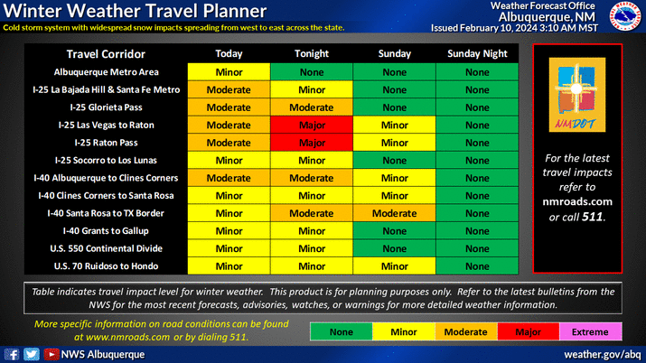
Multiple Winter Storm Warnings and Winter Weather Advisories continue in effect for much of New Mexico through Sunday. New snowfall totals across northeastern New Mexico and parts of the northern mountains are forecast to range from 8" to 14" especially across the higher elevations above 7,500'. Other areas 4" to 8". Lower elevations of the northern two thirds of the state are expected to get 1" to 4".
A Winter Weather Advisory remains in effect for the northern Sacramento Mountains including the Ruidoso, Capitan, and Alto areas. New snowfall of 2" to 4"" is forecast below 7,500' with 3" to 5" above 7,500'. Ski Apache may see another 5" to 11" today into tonight.
A Winter Storm Warning remains in effect for the southern Sacramento Mountains, west slopes below 7,500', and other areas above 7,500' through 11 AM MST Sunday morning. New snowfall of 5" to 9" with 9" to 12" in the higher elevations. Blowing and drifting snow will add to the travel problems and some roads may become closed. This includes the Sunspot, Cloudcroft, Silver Lake, Mescalero Summit, Mountain Park/High Rolls, and Timberon areas.
A Winter Weather Advisory remains in effect for the Mayhill, Sacramento/Weed and Pinon areas through 11 AM MST Sunday. New snowfall totals of 2" to 5" are forecast. Blowing and drifting snow will add to the travel problems and some roads may become closed.
A Winter Storm Watch remains in effect for the South Plains of Texas from the Lubbock area northward. Snowfall totals of 4" to a foot are forecast.
A Winter Storm Watch remains in effect for the Guadalupe Mountains of Eddy and Culberson Counties through Sunday afternoon. New snowfall totals of 4" to 6" are forecast. Blowing and drifting snow will add to the travel problems and some roads may become closed.
Blowing and drifting snow combined with north to northeasterly winds gusting to 35 to 50 mph will cause travel issues across the warning and advisory areas. Especially across the higher elevations and in those areas experiencing the heavier snowfall. Some roads and highways may become closed with near zero visibilities in whiteout conditions. Travel in these areas will be dangerous if not life threatening.
Local power outages are possible especially in those areas that receive a heavy wet snow.
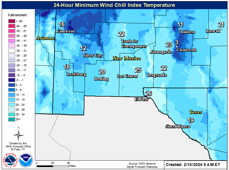
Wind chill temperatures are forecast to drop down to near zero or a little below across parts of the northern mountains and in the higher elevations of the Sacramento and Capitan Mountains above 9,000'.
The jury is still out on how much snow will fall in Chaves, Eddy, and Lea Counties. Current forecast models say an inch or less. But the storm continues to strengthen and is still on a course to the south so these totals could change. Don't be surprised if we end up with more snow than what is being forecast for us now (Saturday morning).
Additional forecast updates are possible today into Sunday along with the possibility of additional Winter Storm Watches, Winter Storm Warnings, and Winter Storm Advisories. So be sure and check my weather web page for updates.
There Are None So Blind As Those Who "Will - Not" To See...107.


Thank you for all your thoroughness. 0.10” of rain and snow at 2:31 am this morning in NE El Paso. The franklins have a good dusting!
ReplyDelete