Posts

Showing posts from September, 2012

Impressive Rainfall Totals For Sept 28-29, 2012.
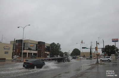
Image
Blog updated at 7:20 PM MDT. (Additional Rainfall Reports Added). Street flooding in Carlsbad yesterday afternoon. NWS Mesonet 24-Hour Rainfall Totals. CoCoRaHS Rainfall Totals. (As Of 7 AM MDT). Eddy County 24-Hour Totals. Eddy County 48-Hour Totals. Lea County 24-Hour Totals. Lea County 48-Hour Totals. Lincoln County 24-Hour Totals. Otero County 24-Hour Totals. Otero County 48-Hour Totals. Midland County Texas 24-Hour Rainfall Totals. Midland County Texas 48-Hour Rainfall Totals. Ector County Texas 48-Hour Rainfall Totals. GRLevel3 2.00 Estimated Rainfall Totals. Midland NWS Doppler Radar. Cannon AFB Doppler Radar. Lubbock NWS Doppler Radar. El Paso/Santa Teresa NWS Doppler Radar. Holloman AFB Doppler Radar. Click On This Link For Additional Totals. Widespread heavy rains fell over southeastern New Mexico and...

One More Shot At Rain Today...Could Be Heavy.

Image
NWS Mesonet High Temperatures. (Thursday Sept 27, 2012). NWS Mesonet 24-Hour Rainfall Totals. (As of 5:30 AM MDT). Another miss for southeastern New Mexico as far as the heavy rainfall that has been forecast so far. We will have another chance today into tonight then we will dry out on Saturday. Scattered rain showers and thunderstorms are forecast today, some of these may be heavy and produce localized flash flooding. Our chances of seeing rain today into tonight are generally in the 40% to 60% range. Our highs today are forecast to be in the low-mid 70's, with the low 80's forecast for Saturday and Sunday. Heavy Rain Falling In West Texas. IR Satellite Image At 6:00 MDT. Midland NWS GRLevel3 2.00 Doppler Radar Snapshots. Map Is Courtesy Of The Midland NWS Office. Map Is Courtesy Of The Midland NWS Office. Map Is Courtesy Of The Lubbock NWS Office. Map Is Courtesy Of The El Paso NWS Office. 06Z...

Heavy Rain & Flash Flooding Possible Today Into Saturday!

Image
Water Vapor Satellite Image At 4:15 AM MDT. RUC 500 MB Analysis At 3 AM MDT. A long fetch of deep tropical moisture (remnants of former Hurricane Miriam) can be seen streaming northeastward from southwest of the Baja Peninsula, and into New Mexico and west Texas on the Water Vapor Satellite Image above. This deep fetch of moisture is being pulled into our state, and local area by a mid-upper level trough of low pressure centered over Colorado. This remnant tropical moisture feed is forecast to continue streaming into our area into Saturday.  Heavy Rain - Flash Flooding Today Into Saturday! Maps Are Courtesy Of The Midland NWS Office. Maps Are Courtesy Of The Lubbock NWS Office. Map Is Courtesy Of The Albuquerque NWS Office. Maps Are Courtesy Of The El Paso NWS Office. 06Z GFS Temp Departure From Normal Forecast. Valid At Noon Today. Radar is showing scattered rain showers and a few isolated thunderstorms coverin...

Current National Weather Service Watches/Warnings In Effect.

New Mexico

Chaves County Plains & Mtn's

Eddy County

Culberson County

Lea County

Lincoln County

Otero County

Current US Temps

Current US Wind Chill/Heat Index Temperatures

WPC 7-Day Precipitation Forecast

Roswell Live EarthCam

Ruidoso Live Webcam

Cloudcroft Live Webcam

NWS Midland 3-Day Precipitation Forecast

NWS Midland 3-Precipitation Chances

New Mexico 3-Day Precipitation Forecast

New Mexico Precipitation Chances

NWS El Paso 3-Day Precipitation Forecast

NWS El Paso Precipitation Chances

New Mexico 3-Day Snowfall Forecast

New Mexico Snowfall Chances

NWS El Paso 3-Day Snowfall Forecast

NWS El Paso Snowfall Chances

US 24-Hour Precipitation Forecast

US 3-Day Precipitation Forecast

US 24-Hour Snowfall Forecast

US 3-Day Snowfall Forecast