Posts

Showing posts from October, 2013

Happy Halloween 2013!

Image
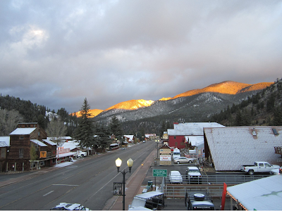
Happy Halloween From Red River, New Mexico. Halloween Temperatures. Courtesy Of The Midland NWS Office. Courtesy Of The Lubbock NWS Office. Courtesy Of The Albuquerque NWS Office. Valid @ 5 PM MDT This Afternoon. Valid @ 5 PM MDT This Evening. Valid @ 7 PM MDT This Evening. Valid @ 8 PM MDT This Evening. Valid @ 9 PM MDT This Evening. A sunny Halloween is in store for the area today. Our afternoon high temperatures across southeastern New Mexico will range from the low-mid 70's. Northwest to west winds at around 10 -20 mph are anticipated across the southeastern plains. A Wind Advisory is in effect for the Ruidoso area where northwest to west winds of 25 - 35 mph with gusts near 50 mph are expected today. By sunset this evening the winds will begin to die off but there will still be a westerly breeze across the southeastern plains at around 5 - 15 mph...so it will be a little on the chilly side. By 9 pm our temps will be falling

Storm Is Too Far To The North.

Image
Red River, New Mexico This Morning. 12Z/6 AM MDT NAM 500 MB Analysis. Valid @ 6 AM MDT This Morning. Water Vapor Satellite Image @ 7:45 AM MDT This Morning. Our anticipated strong winter-like storm is going to be somewhat of a let down. At sunrise this morning the storm was beginning to split into an elongated mid-level trough of low pressure. Part of the storm is centered over northwestern Arizona while the core of the storm was centered over western Wyoming. 12Z/6 AM MDT NAM-WRF Snowfall Accumulations. A week ago the models were going nuts with this storm...forecasting a big snow storm from the Rockies eastward into the plains. This is not to be now. A Winter Weather Advisory is in effect for the northwestern Highlands and the San Juan Mountains of northern New Mexico through early this evening. 1" - 3" of snow is forecast with higher totals across the higher peaks and summits.  A Wind Advisory is in effect for the Ruidoso, Cloudcroft

Chance For T-Storms This Afternoon Into Wednesday.

Image
Sunrise Over The Salt Lakes Located Southeast Of Carlsbad,  New Mexico Monday Morning. The Sun Was Peeking Over A Fog Bank 06Z/ Midnight NAM 500 Analysis. Deep Mid-Upper Level Low Parked Over Nevada. IR Satellite Image Of The Remnant Moisture From Tropical Storm Raymond Streaming Northeastward Into New Mexico. Our large mid-upper level storm was still located over Nevada as of midnight last night. The models slowly begin to open this closed low up and move it eastward later today into Wednesday. Copious amounts of mid and high level moisture continue to stream northeastward from Tropical Storm Raymond .  Scattered thunderstorms are forecast for the southeastern plains and parts of west Texas later this afternoon, and our chances for getting wet will increase tonight, and continue into tomorrow. The dryline will sharpen up over the local area as the storm to our northwest begins to open up and move eastward. Strong gusty southwesterly winds will rake t

Unusually Deep Mid-Upper Level Storm Headed Our Way.

Image
Winds at ~ 0500 EDT lulled to about 50mph ( http:// www.mountwashington.org/ weather/conditions.php ) allowing the Night Observer (Ryan Knapp) to weight down and set up his camera long enough to “light write” a message with his headlamp – GO SOX! Unusually Deep Mid-Upper Level Storm. Courtesy Of NWS Albuquerque. Courtesy Of NWS Midland. 06Z/Midnight MDT NAM 500 MB Analysis. 06Z/Midnight MDT NAM Surface Cape Forecast. Valid @ 3 PM MDT Tuesday. Storm Prediction Center (SPC) Day 2 Severe Weather Outlook. IR Satellite Image Of Hurricane Raymond @ 5:30 AM MDT. An unusually deep mid-upper level storm is slowly sinking southward over northern California early this morning. Unfortunately there still remains more questions about where this storm is headed than there are answers.  A slower and more southward track of the storm would mean more rain and snow for New Mexico...and a possible influx of the remnant moisture from Hurricane Raymond

Big Storm Next Week - Questionable Impacts.

Image
NAM 500 MB Forecast @ 11 AM MST Monday. Overall the models have settled down some...but the overall outlook is still uncertain. They basically agree that short wave now getting ready to round the upper-level ridge and drop into the Pacific Northwest will form a closed mid-upper level low over Nevada by Monday. Just how far south and west it sinks is still questionable. Of course this will have a huge impact on just what kind of weather will develop over New Mexico. There some indications that the dry line will set up along or near the Texas/New Mexico border on Tuesday and Wednesday. If the storm to our west digs further south than forecast then the dry line will get pulled back to the west...giving the eastern and southeastern sections of the state a better shot at thunderstorms. Still watching to see if Hurricane Raymond's moisture gets pulled up into the area by this strong approaching mid-upper level storm. There is the potential for this to happen if the storm

Friday's Rainfall Totals.

Image
NWS Mesonet 24-Hour Rainfall Reports As Of 5:30 AM MDT. A fairly widespread area of light to moderate rainfall covered the area yesterday. The heaviest rainfall totals fell over the Sacramento Mountains.  The Truth Is Stranger Than Fiction!   My Web Page Is Best Viewed With Google Chrome.

Flip Flop Time With The Models Forecasts Of Next Weeks Storm.

Image
U.S. GFS Model Forecasts. 500 MB Forecast Valid @ 6 AM MDT Monday. 500 MB Forecast Valid @ 6 AM MDT Tuesday. 500 MB Forecast Valid @ 6 AM MDT Wednesday. Temperature Anomaly Departures From Normal. Valid @ 6 AM MDT Wednesday. Accumulated Snowfall Valid @ 6 PM MDT Wednesday. European (ECMWF) Model Forecasts. 500 MB Forecast Valid @ 6 AM MDT Monday. 500 MB Forecast Valid @ 6 AM MDT Tuesday. 500 MB Forecast Valid @ 6 AM MDT Wednesday. Temperature Anomaly Departures From Normal. Valid @ 6 AM MDT Wednesday. Total Snowfall Valid @ 6 PM MDT Wednesday. Canadian (GEM) Model Forecasts. 500 MB Forecast Valid @ 6 AM MDT Monday. 500 MB Forecast Valid @ 6 AM MDT Tuesday. 500 MB Forecast Valid @ 6 AM MDT Wednesday. Accumulated Snowfall Valid @ 6 PM MDT Wednesday. Courtesy Of AccuWeather. This mornings 12Z/6 AM MDT runs of the computer forecast models concerning our potential Halloween winter-

Spooky Weather For Halloween Next Week?

Image
This Mornings 12Z/6 AM MDT Canadian Model (GEM) 500 MB Forecast Valid @ Noon MDT Wed, Oct 30, 2013. This Mornings 12Z/6 AM MDT Canadian Model (GEM) Temperature Forecast Valid @ 6 PM MDT Wed, Oct 30, 2013. This Mornings 12Z/6 AM MDT Canadian Model (GEM)  Snowfall Forecast Valid @ 6 PM MDT Wed, Oct 30, 2013. This mornings 12Z or 6 AM MDT run of the various computer models continues to be a quagmire of possible solutions concerning next weeks winter-like Halloween storm. I thought it was interesting that the Canadian model is swinging the closed mid-upper level storm into the Four Corners by next Wednesday, then opens it up as a trough of low pressure over central/southern New Mexico Wednesday night, as it begins to lifts northeastward and out of the state. Again you simply cannot latch onto one model and say this is what is going to happen. As I mentioned in this mornings blog there will be changes within the models between now and the first of next week. S

Current Watches In Effect

Storm Prediction Center (SPC) Day 1 Severe Weather Outlook

SPC Mesoscale Discussions

Current NWS National Watches/Warnings In Effect

Current NWS National Watches/Warnings In Effect
Click On The Map For The Latest Updates

New Mexico

NWS Regional Radar

NWS Regional Radar

GOES-East - Sector view: Southern Rockies - GEOColor

Current US Temps

Current US Wind Chill/Heat Index Temperatures

NWS Midland Radar

NWS Midland Regional Forecast

NWS Midland Regional Forecast

NWS Midland Regional Forecast

Cannon AFB Radar

NWS Albuquerque Radar

NWS Albuquerque Regional Forecast

NWS Albuquerque Regional Forecast

NWS Albuquerque Regional Forecast

NWS Albuquerque Regional Forecast

Holloman AFB Radar

NWS El Paso Radar

NWS El Paso Regional Forecast

NWS Lubbock Radar

NWS Lubbock Regional Forecast.

NWS Lubbock Regional Forecast

NWS Lubbock Regional Forecasts

NWS Lubbock Regional Forecast

NWS Forecast High Temps Today

NWS Forecast Low Temps Tonight

24-Hour Minimum Wind Chill Forecast

NWS Albuquerque Storm Total Snowfall Forecast

NWS Albuquerque Storm Total Rainfall Forecast

NWS Midland Storm Total Rainfall Forecast

NWS El Paso Storm Total Rainfall Forecast

Average Daily High/Low Temperatures & Rainfall

Average Daily High/Low Temperatures & Rainfall