Posts

Showing posts from June, 2022

Current Date & Time

New Daily Record High Temperatures - June 2022.

Image
New Daily Record High Temperatures. (June 2022). With the widespread moderate to heavy rainfall and cooler temperatures over the state over the past couple of weeks, it has been easy to forget how hot the first half of the month was. A total of 111 new daily record high temperatures were set. Leading the pack was the Tucumcari Aiport which set a new all-time June record high temp as well as a new all-time high temp for them of 112º set on the 11th. Their previous all-time record high was 110º set on July 13, 2020. The Carlsbad and Roswell Airports both set new daily record highs of 111º on the 11th and 12th. The Artesia Climate Co-Op Station set a new daily record of 110º on the 13th.  There Are None So Blind As Those Who "Will - Not" To See...107.
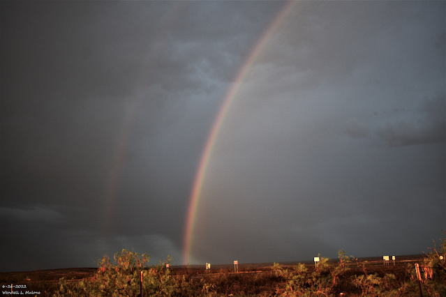
The Rains Came - So Did The Flooding.

Image
Carlsbad, New Mexico's Wet Microburst.   NWS Midland Dual Pol Doppler Radar Snapshot. (3:11 PM MDT Sunday, June 26, 2022). A  thunderstorm quickly became severe as it rolled into the east side of Carlsbad around 3:15 PM MDT Sunday afternoon. A Personal Weather Station (PWS) Ridgecrest Subdivision  located on the east side of Carlsbad clocked a peak wind gust of 75 mph during the wet microburst it produced. That station also measured 1.60" of rainfall in less than an hour and the 24-hour total came to 2.28". Chaves & Eddy County Heavy Rainfall Totals. ROSWELL, N.M.  (KRQE) – Severe flooding over the weekend in southeast New Mexico has caused multiple homes in Roswell to be lost. Roswell Community Disaster Relief Services say three homes have flooded on the north side of town, leaving those families displaced. Courtesy Of The City Of Roswell Facebook Page. Sunday (June 26) flooding impacts: Bridge on East Mescalero Road at La Jara Road over Berrendo River (wh...

6-22-2022 Rainfall Summary - Weekly Totals & Month-To-Date Totals.

Image
June 19, 2022. West Of Brantley Lake. Looking West On St Hwy 137. CoCoRaHS 7-Day Rainfall Totals. (June 16 - 22, 2022). CoCoRaHS June 2022 Rainfall Totals. (June 1 - 22, 2022). Weather Underground 7-Day Rainfall Totals. (June 16 - 22, 2022). New Mexico Mesowest Rainfall Totals. 7-Day & 30-Day Totals). New Mexico Rainfall Totals. 5-Day Totals. (As Of 6 AM MDT Wednesday, June 22, 2022) 7-Day Totals. (As Of 6 AM MDT Wednesday, June 22, 2022) 30-Day Totals. (As Of 6 AM MDT Wednesday, June 22, 2022) Selected 7-Day & Month-To-Date Rainfall Totals. (As Of 9 AM MDT Wednesday, June 22, 2022). Wimsatt PWS - Roachshack 3.52"  8.16" Cox Canyon PWS - Ponderosa Pines 2.86" 7.71" Wimsatt PWS - Wimsatt Cabin 2.62"  7.29" Bell Canyon PWS 4.35"  5.30" Capitan 4.3 WSW 4.68"   5.08" Cloudcroft PWS - Dalton's Mountain 1.99"  4.38" Cloudcroft 4.0 E 4.00"   4.21" Nogal 4.6 SSE 3.35"  3.96" Alto PWS 3.38"  ...

My Blog Archive List (July 2010 - August 2025).

Show more

My Current Weather Conditions

MY CoCoRaHS Precipitation Data

NWS Albuquerque 2026 Winter Outlook (Updated Nov 19th).

NWS Midland Web Page

NWS Midland Web Page
Click On The Map To Open It Up

SE New Mexico & West Texas Precipitation Forecasts

Eddy County

Guadalupe Mtns Eddy & Culberson County

Lea County

NWS Midland Hazardous Weather Outlook

NWS Midland Hazardous Weather Outlook
Click On The Image To See The Rest Of The Outlooks

NWS Midland Hazardous Weather Outlook

NWS Midland Hazardous Weather Outlook

NWS Midland Hazardous Weather Outlook
Click On The Image To See The Rest Of The Outlooks

NWS Midland Hazardous Weather Outlook

NWS Midland Forecast High Temperatures Today

NWS Midland Forecast Low Temperatures Tonight

NWS Midland Graphic Forecast

NWS Midland Graphic Forecast
A cold front has moved through the area this morning, bringing in colder temperatures. Clear skies and decreasing winds will help temperatures to fall below freezing for the first time across southern and central Lea County, portions of the northern Permian Basin, and Davis Mountains late tonight through Monday morning.

NWS Midland Graphic Forecast

NWS Midland Graphic Forecast
An upper-level system brings a low chance of light rain or snow flurries to mainly northern and eastern portions of the area Tuesday morning (10-20% chances). The relatively better chance of seeing flurries will be across SE New Mexico, the NW Permian Basin, and in the Guadalupes. Little to no accumulation is expected where flurries do occur.

NWS Midland Forecast Graphic

NWS Midland Forecast Graphic
Temperatures remain below normal across southeast New Mexico and west Texas. Many locations in the Permian Basin, SE New Mexico, and in/around the Guadalupe and Davis Mountains will experience lows at or below freezing over the course of the week before temperatures start warming towards the weekend.

NWS Albuquerque Web Page

NWS Albuquerque Web Page
Click On The Map To Open It Up

NWS Albuquerque New Mexico Precipitation Forecasts

New Mexico

Chaves County Plains & Mtn's

Lincoln County

NWS Albuquerque Hazardous Weather Outlook

NWS Albuquerque Hazardous Weather Outlook

NWS Albuquerque Forecast High Temperatures Today

Today's High Temperature Difference From Climatology

NWS Albuquerque Forecast Low Temperatures Tonight

Tonight's Low Temperature Difference From Climatology

NWS Albuquerque Wind Chill Forecast

NWS Albuquerque Peak Wind Gust Forecast

NWS Albuquerque Graphic Forecast

NWS Albuquerque Graphic Forecast
Another quick-hitting storm will bring light rain and snow to the area Monday morning through late Monday night. Light snow accumulations are likely, with a low chance for up to 6 inches over the peaks of the northern mountains.

NWS Albuquerque Graphic Forecast

NWS Albuquerque Graphic Forecast
Temperatures today will range for 3 degrees below average in northern NM to as much as 15 degrees below average in the eastern plains. Monday morning will also feel chilly with seasonable morning lows.

NWS Albuquerque Graphic Forecast

NWS Albuquerque Graphic Forecast
Temperatures will be slightly below normal early in the week, warming above average mid to late week. Mornings will be chilly with temps below freezing in most areas. Light lower elevation rain/high terrain snow chances for some the 2nd half of Monday into early Tuesday morning.

NWS El Paso Web Page

Southern New Mexico & Far West Texas Precipitation Forecasts

Texas

Otero County

NWS El Paso Hazardous Weather Outlook

NWS El Paso Hazardous Weather Outlook
Click On The Image To See The Rest Of The Outlooks

NWS El Paso Forecast High Temperatures Today

NWS El Paso Forecast Low Temperatures Tonight

NWS El Paso Wind Chill Forecast

NWS El Paso Graphic Forecast

NWS El Paso Graphic Forecast
Cooler temperatures and some light, easterly breezes for Sunday.

NWS El Paso Graphic Forecast

NWS El Paso Graphic Forecast
Rain/Snow Chances for Tuesday Morning Hide Caption

NWS El Paso Graphic Forecast

NWS Lubbock Web Page

NWS Lubbock Web Page
Click On The Map To Open It Up

NWS Lubbock South Plains Precipitation Forecasts

NWS Lubbock Hazardous Weather Outlook

NWS Lubbock Hazardous Weather Outlook

NWS Lubbock Hazardous Weather Outlook
Click On The Image To See The Rest Of The Outlooks

NWS Lubbock Hazardous Weather Outlook

NWS Lubbock Hazardous Weather Outlook
Click On The Image To See The Rest Of The Outlooks

NWS Lubbock Hazardous Weather Outlook

NWS Lubbock Hi Temperature Forecast Today

NWS Lubbock Low Temperature Forecast Tomight

NWS Lubbock Graphic Forecast

NWS Lubbock Graphic Forecast
Potential for snow and rain showers overnight Monday into Tuesday remains. Much of the precipitation type is expected to be snow, however the Rolling Plains could see a wintry mix. Little accumulation is expected if snow does occur.

NWS Lubbock Graphic Forecast

NWS Lubbock Graphic Forecast
Cold temperatures continue into Monday with highs in the 40s for much of the forecast area. Potential remains for snow and rain showers overnight Monday through Tuesday afternoon. Little accumulation is expected if snowfall does occur.

NWS Lubbock Graphic Forecast

NWS Lubbock Graphic Forecast
The rest of the work week, including Thanksgiving will be cold with highs in the 40s. There will be a slight warm up by the weekend.

NWS Lubbock Graphic Forecast

NWS Lubbock Graphic Forecast
With early morning lows expected almost every morning this week, remember to protect your property and pets!

My Rainfall Totals - 2.1 NNW Downtown Carlsbad

My Rainfall Totals - 2.1 NNW Downtown Carlsbad

My Seasonal Snowfall Totals - 2.1 NNW Downtown Carlsbad

My Seasonal Snowfall Totals - 2.1 NNW Downtown Carlsbad

Disclaimer

This blog and its contents are for informational purposes only! Always have multiple sources of information available to rely upon during severe weather. Do not rely solely on the Internet. Be weather-aware, plan ahead, have a backup plan, and be ready to act before severe weather strikes your location.