Here We Go Again - Another High Wind/Blowing Dust/Critically Dangerous Fire Weather Event On Tuesday.
My 11" CoCoRaHS Rain Gauge.
Friday's Dust Storm Deposited A Pecan Leaf, Grass, And Dirt In It.
(March 7, 2025).
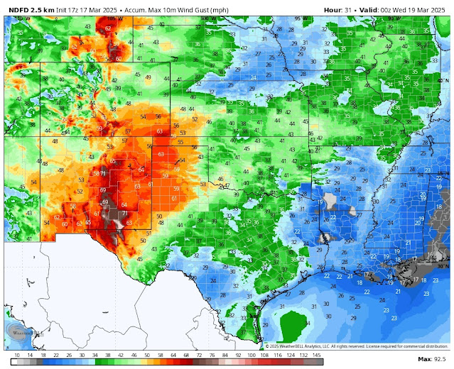
Here we go again. Yet another high wind, blowing dust, and critically dangerous to extremely critically dangerous fire weather event is slated to get underway this afternoon into Tuesday night. High winds are forecast to ramp across most of the state late tomorrow morning into the afternoon and evening hours. Critically dangerous fire weather conditions will continue this week with strong winds again on Thursday and Friday. Long-range forecasts offer no real hope for drought relief.
GFS 300 MB (30,000' MSL) Jet Stream Forecast.
GFS 500 MB (18,000' MSL) Jet Stream Forecast.
Valid At 6 PM MDT Tuesday, March 18, 2025.
GFS 700 MB (10,000' MSL) Forecast.
High Winds - Widespread Blowing Dust - Extremely Critically Dangerous Fire Weather Conditions Tonight Into Tuesday Night.
A strong Pacific cold front is forecast to enter the Four Corners area by sunrise Tuesday. It will then sweep rapidly across the state from west to east. By sunset Tuesday the front is forecast to be approaching the DFW area.
At the mid-upper levels of the atmosphere, a potent jet stream wind speed max will dissect the state from southwest to northeast on Tuesday. Forecast winds aloft once again are expected to be very strong. With strong daytime heating and atmospheric mixing these strong winds aloft will mix down to the surface starting later tonight and last into Tuesday night over the area.
Another Damaging Wind Event.
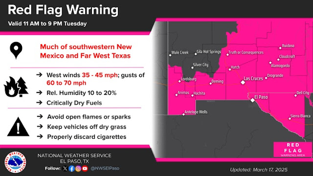
Strong westerly winds will develop this afternoon over western and southern New Mexico and then rapidly spread eastward across the state tonight into Tuesday. These winds will increase to sustained speeds of 35 to 45 mph with gusts to 60 to 70 mph in most areas under a High Wind Warning.
Numerous High Wind Warnings, Watches, Wind Advisories, Blowing Dust Advisories, Red Flag Warnings, and Fire Weather Watches remain in effect for most of New Mexico. Additional upgrades and or warnings and advisories may be needed in some locations.
Across the Sacramento mountains strong westerly winds will increase tonight and on Tuesday become sustained at 40 to 50 mph with gusts to 75 mph.
Across the southeastern plains, strong westerly winds will increase to sustained speeds of 35 to 45 mph with gusts to 70 mph on Tuesday.
In the Guadalupe mountains strong westerly winds will increase to sustained speeds of 50 to 70 mph with gusts near 90 mph on Tuesday.
Some power poles, power lines, and utility lines may be blown down. Some trees and fences, along with outbuildings and barns, may be damaged or blown down. Farmland irrigation systems may be damaged or blown away, especially if they are not staked down and have water running in them. High-profile vehicles such as Semi's, Campers, Rv;s, and others may be blown off north-south facing roads. Road closures are possible in some areas due to the high winds and localized brownout conditions.
Areas of blowing dust will develop on Tuesday across areas of southern, south-central, and southeastern New Mexico then spread northeastward into the eastern plains. Localized drops in the visibility due to blinding dust storms with little to no advanced warning will occur, especially in and near our more dust-prone areas. Widespread blowing dust is expected to impact much of the area on Tuesday.
Widespread brownout conditions due to blinding dust storms born upon 60 to 80+ mph westerly wind gusts tonight into Friday will make travel over much of the area extremely dangerous and even life-threatening! Widespread areas of blowing dust will create near-zero to zero visibility in many areas. Road closures are a strong possibility in these conditions. Travel on our roads and highways will become dangerous and life-threatening in these blinding brownouts/dust storms.
Not only southeastern New Mexico but other nearby areas have a long history of multiple vehicle pileups in these blinding dust storms. Many times with injuries and, sadly, sometimes fatalities. Unless you absolutely must drive in the area on Tuesday, please exercise extreme caution and consider not doing so unless it's an emergency.
Critically To Extremely Critically Dangerous Fire Weather Conditions!
Critically Dangerous Fire Weather Conditions exist for today. Extremely Critically Dangerous Fire Weather Conditions will occur on Tuesday. Red Flag Warnings are already flying, and these will continue into Tuesday.
Large, rapidly moving, and life-threatening wildfires will be possible during this high-wind event. Especially if power poles and power lines are blown down. Any wildfire or forest fire that starts will have the potential to rapidly spread and grow in the high winds. And they will be very hard to contain, if at all. Should any wildfire develop smoke from them, could add to the visibility hazards on our roads and highways, especially if it mixes in with the blowing dust.
Please refrain from any outdoor activity that involves the use of sparks or flames. Do not toss cigarettes out of your vehicle or pull over onto the side of the road in tall grass. The hot exhaust pipes and catalytic converters on your vehicles may start a fire. Do not let chains drag on the payment behind your vehicle either, as they may cause sparks that can cause a fire.
Stay Informed & Safe Tonight Into Tuesday Night.
Numerous High Wind Warnings, High Wind Watches, Wind Advisories, Red Flag Warnings, Fire Weather Watches, are in effect for the state and nearby areas. Additional warnings, advisories, and changes to some of our forecasts will likely be issued today through Tuesday.
So, please click on this link to view the latest updates. Or, visit my weather web page often for all of the latest updates. Or your favorite media outlet.
Area Forecast Discussion
National Weather Service Midland/Odessa TX
1244 PM CDT Mon Mar 17 2025

...New AVIATION...

.KEY MESSAGES...
Updated at 1235 PM CDT Mon Mar 17 2025

- Critical to extreme fire weather conditions are expected across
  the region today and Tuesday.

- Strong winds return to west Texas and southeast New Mexico
  Tuesday afternoon. A High Wind Watch is in effect for parts of
  the area, and additional products are likely to be issued closer
  to time (> 70% confidence).

- No precipitation chances through the extended, with episodic
  increased fire weather whenever gusty winds are present.
Area Forecast Discussion...UPDATED
National Weather Service Albuquerque NM
1151 AM MDT Mon Mar 17 2025

...New UPDATE, AVIATION...

.KEY MESSAGES...
Updated at 1132 AM MDT Mon Mar 17 2025

- Winds begin strengthening on Monday, with windy conditions
  across much of eastern and northeastern NM. Critical fire
  conditions will allow for the rapid spread and growth of any
  fire that starts.

- A potent spring storm impacts the region on Tuesday, bringing
  strong winds area wide, blowing dust to much of eastern and
  south central NM, and snow/blowing snow to the northern
  mountains. Critical fire weather conditions also return and will
  continue to promote rapid fire spread across much of eastern and
  central NM.

- Gusty winds and critical fire weather conditions are possible
  again Thursday and Friday across eastern NM.

&&

.UPDATE...
Issued at 1132 AM MDT Mon Mar 17 2025

An early look at the latest 12Z model guidance supports an upgrade
of the High Wind Watches within the Rio Grande Valley to High Wind
Warnings for Tuesday. Subsidence behind the Pacific cold front
during the afternoon hours supports peak wind speed potential
impacting these areas. Have also expanded the High Wind Warning
westward to the southwestern mountains and San Agustin Plains in
Catron and Socorro Counties, as well as the Continental Divide
between Gallup and Grants eastward into the west-central
highlands that include Grants and Laguna and Acoma Pueblos.
Adjacent Wind Advisories have also been introduced to areas along
the AZ border from the Chuska Mountains southward through Gallup
and Zuno Pueblo as well as the San Francisco River Valley.

&&

.SYNOPSIS...
Issued at 329 AM MDT Mon Mar 17 2025

The pleasant weather from the last couple of days will be shortlived
as conditions deteriorate over the next couple of days. Another
spring storm will start to make things windy on Monday, with gusts
becoming strong to damaging on Tuesday. Critical fire conditions and
blowing dust will be the main concerns, particularly for the eastern
half of the state. Northern and western areas will get some light
precipitation, with snow mainly for the northern mountains. Some
snow and blowing snow could impact areas in far northeast New Mexico
on Tuesday night as the storm exits the region and a backdoor cold
front pushes through. Conditions will remain breezy for eastern New
Mexico through the end of the week, with wind speeds picking up on
Friday as another system makes its way through intermountain west.
With conditions looking to remain dry for the majority of the state,
fire weather and blowing dust will once again be the main concerns
for the extended forecast.

&&
Area Forecast Discussion
National Weather Service El Paso TX/Santa Teresa NM
1135 AM MDT Mon Mar 17 2025

...New AVIATION...

.KEY MESSAGES...
Updated at 1127 AM MDT Mon Mar 17 2025

 - Upper ridge over the area will lead to quiet weather for Monday.

 - New Pacific storm moves in Tuesday with strong winds and
   blowing dust, and more critical fire weather conditions.

 - Quiet again Wednesday into next weekend with typical afternoon
   breezes.

&&
There Are None So Blind As Those Who "Will - Not" To See...107.


-precipitation-outlook-03-17-2025.png)


Fire west of Mayhill tonight off Highway 82 about MM 31
ReplyDelete