Current Date & Time

Little Bear Fire - Ruidoso, New Mexico Update. June 16, 2012.


#LittleBearFire June 16, 9 am – Firefighters Keep Eye on Weather as Clouds Build

Fire Information: (575)258-6900
Size: approx. 38,144 acres
Containment: 51 %
Resources Committed: Personnel: 1,425; crews: 12 Type 1, 23 Type 2; engines: 85; helicopters: 6 Type 1, 3 Type 2, 2 Type 3; dozers: 13; water tenders: 19
Today’s Weather: 70-80 degrees, relative humidity 30-40%, wind SW 10-20 mph gusting to 35 mph
Injuries: 3
Structures destroyed: 234 (224 residential structures and 10 outbuildings)
Road Closures: NM 532 (Ski Run Road) from NM 48 junction to Forest Road 127A is open to residents only
Area Closures: The entire White Mountain Wilderness, and that portion of the Smokey Bear District south of US 380 to the Mescalero Apache Reservation boundary including a large area east and north of Ruidoso to the south boundary of the Fort Stanton Recreation Area.
Summary: Cool, cloudy weather and higher humidity present the first real chance of rain since the beginning of the Little Bear Fire. Firefighters will remain vigilant for flash flooding in canyons on the fire today. Interior islands of unburned fuel will smolder today, creating very little smoke. Crews will be improving containment line on the west side. Patrol and mop up continue around the remainder of the fire.
All subdivisions except Angus and Bonita Park are now open. Ski Run Road and Bonita Lake are open to residents only. Residents returning to their homes should be alert for fire vehicle traffic.
Meetings: A community meeting will be conducted in the main gymnasium of Ruidoso High School, 125 Warrior Road at 7:00 p.m. A community meeting will also be conducted at the fairgrounds in Capitan at 7:00 p.m.
Evacuations: All campgrounds west of Bonito Lake; Angus and Bonita Park.
Shelters: Ruidoso High School at 125 Warrior Road, and Trinity Baptist Church in Capitan.Pets and livestock may be taken to Pet Paradise in La Luz (575-434-1784), Otero County fairgrounds in Alamogordo (575-434-0788, 575-491-7553, or 575-491-4643), Lincoln County fairgrounds in Capitan (575-808-2814), Humane Society of Lincoln County in Ruidoso (575-257-9841 or 575-378-1039), Ruidoso Animal Clinic (575-257-4027), Dunagan Farms in Ruidoso (575-257-9549 or 575-621-4056), New Mexico Livestock Board (575-649-2758), Carrizozo Animal Shelter (575-648-2351), Thundering Paws in Alto (575-336-7297), and Yolanda and Robert Espinoza (575-354-9019).
 Many residents of the community have expressed interest in making monetary donations to the firefighting organizations. Local fire departments should be considered first. Additionally, the following websites provide avenues for making donations: http://www.wffoundation.org/, and http://www.redcrossnewmexico.org/.
Information on wildland fire smoke and your health can be found on the New Mexico Department of Health’s website at: https://nmtracking.unm.edu/eh_alerts/, or call the New Mexico statewide health line at (877)304-4161. Additional websites for accurate fire information are Facebook.com/LittleBearFireNM, Twitter.com/T1SWIMT,Flickr.com.photos.lincolnnationalforest (maps), and Flickr.com/photos/wildland-fires-2012/(photos).
Start Time/Date:Monday, June 4, 2012
Location: Smokey Bear Ranger District, Lincoln NF, including White Mountain Wilderness
Cause: Lightning
Fuels: Mixed conifer, ponderosa pine

The Truth Is Stranger Than Fiction!

 My Web Page Is Best Viewed With Google Chrome.

Comments

My Blog Archive List (July 2010 - August 2025).

Show more

My Current Weather Conditions

MY CoCoRaHS Precipitation Data

NWS Albuquerque 2026 Winter Outlook (Updated Nov 19th).

NWS Midland Web Page

NWS Midland Web Page
Click On The Map To Open It Up

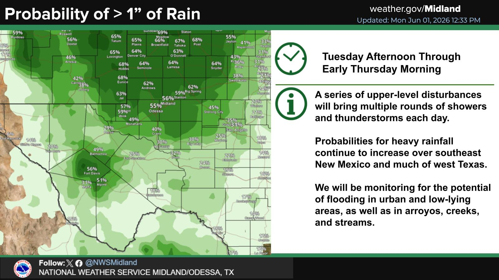
SE New Mexico & West Texas Precipitation Forecasts

Eddy County

Guadalupe Mtns Eddy & Culberson County

Lea County

NWS Midland Hazardous Weather Outlook

NWS Midland Hazardous Weather Outlook
Click On The Image To See The Rest Of The Outlooks

NWS Midland Hazardous Weather Outlook

NWS Midland Hazardous Weather Outlook

NWS Midland Hazardous Weather Outlook

NWS Midland Hazardous Weather Outlook
Click On The Image To See The Rest Of The Outlooks

NWS Midland Forecast High Temperatures Today

NWS Midland Forecast Low Temperatures Tonight

NWS Midland Peak Wind Gust Forecast

NWS Midland Graphic Forecast

NWS Midland Graphic Forecast
A Dense Fog Advisory is in effect until 9 AM MST Saturday for the Eddy County Plains, as well as Northern and Central Lea County. When visibility is low, drive slow!

NWS Midland Forecast Graphic

NWS Midland Forecast Graphic
Patches of dense fog are once again expected tonight into Saturday morning, mainly in SE New Mexico, SE Permian Basin, and along portions of the Pecos River Valley. Skies clear and fog dissipates by Saturday afternoon, giving way to a very pleasant Saturday afternoon across the area!

NWS Midland Graphic Forecast

NWS Midland Graphic Forecast
Following a front Saturday evening/Saturday night, temperatures fall below normal across southeast New Mexico and west Texas. Highs stay below normal throughout next week thanks to reinforcing shots of cold air. A few locations (mainly in the northern Permian Basin, SE New Mexico, and in the Davis Mountains) say see their first freeze Monday and/or Wednesday mornings.

NWS Albuquerque Web Page

NWS Albuquerque Web Page
Click On The Map To Open It Up

NWS Albuquerque New Mexico Precipitation Forecasts

New Mexico

Chaves County Plains & Mtn's

Lincoln County

NWS Albuquerque Hazardous Weather Outlook

NWS Albuquerque Hazardous Weather Outlook

NWS Albuquerque Forecast High Temperatures Today

Today's High Temperature Difference From Climatology

NWS Albuquerque Forecast Low Temperatures Tonight

Tonight's Low Temperature Difference From Climatology

NWS Albuquerque Wind Chill Forecast

NWS Albuquerque Peak Wind Gust Forecast

NWS Albuquerque Graphic Forecast

NWS Albuquerque Graphic Forecast
Dense Fog is likely to return to areas of east-central and southeastern New Mexico tonight into Saturday morning. Low visibility as low as a quarter mile will impact the morning commute in these areas.

NWS Albuquerque Graphic Forecast

NWS Albuquerque Graphic Forecast
Gusty westerly to northwesterly winds are forecast across much of NM Saturday afternoon. Crosswinds will yield difficult travel conditions on area highways for high profile vehicles.

NWS Albuquerque Graphic Forecast

NWS Albuquerque Graphic Forecast
A cold front brings light snow accumulations to the high terrain of northern NM Saturday afternoon and night. Minor winter travel impacts from slick roads are likely through high mountain passes.

NWS Albuquerque Forecast Grpahics

NWS Albuquerque Forecast Grpahics
Colder temperatures sweep in behind a cold front Saturday night into Sunday morning when many areas are forecast to see a hard freeze.

NWS Albuquerque Graphic Forecast

NWS Albuquerque Graphic Forecast
Colder temperatures stick around into next week with most days starting off near or below freezing over much of New Mexico.

NWS El Paso Web Page

Southern New Mexico & Far West Texas Precipitation Forecasts

Texas

Otero County

NWS El Paso Hazardous Weather Outlook

NWS El Paso Hazardous Weather Outlook
Click On The Image To See The Rest Of The Outlooks

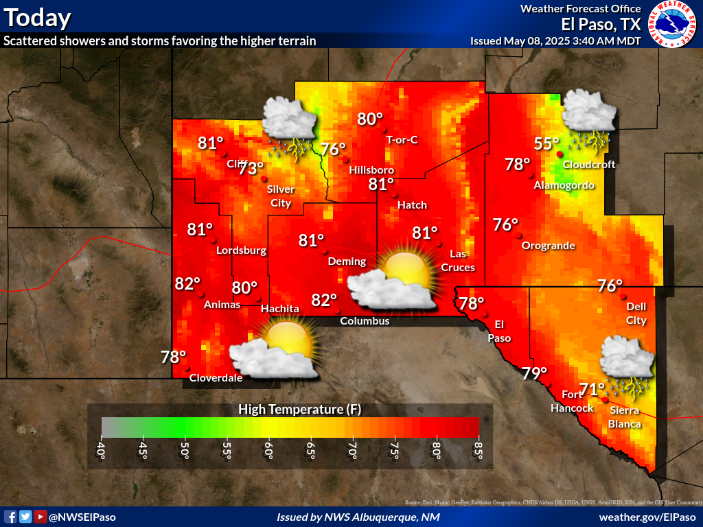
NWS El Paso Forecast High Temperatures Today

NWS El Paso Forecast Low Temperatures Tonight

NWS El Paso Wind Chill Forecast

NWS El Paso Peak Wind Gust Forecast

NWS El Paso Graphic Forecast

NWS El Paso Graphic Forecast
Temperatures for tomorrow will be below average by about 2 to 8 degrees. Skies will be partly cloudy with little chance for rain. Breezy winds at 15 to 25 mph out of the W and NW.

NWS El Paso Graphic Forecast

NWS El Paso Graphic Forecast
Dependent on how early the winds die down Sunday morning, parts of New Mexico could see their first freeze of the season.

NWS Lubbock Web Page

NWS Lubbock Web Page
Click On The Map To Open It Up

NWS Lubbock South Plains Precipitation Forecasts

NWS Lubbock Hazardous Weather Outlook

NWS Lubbock Hazardous Weather Outlook

NWS Lubbock Hazardous Weather Outlook
Click On The Image To See The Rest Of The Outlooks

NWS Lubbock Hazardous Weather Outlook

NWS Lubbock Hazardous Weather Outlook
Click On The Image To See The Rest Of The Outlooks

NWS Lubbock Hazardous Weather Outlook

NWS Lubbock Hi Temperature Forecast Today

NWS Lubbock Low Temperature Forecast Tomight

NWS Lubbock Graphic Forecast

NWS Lubbock Graphic Forecast
Low clouds and some fog return tonight on mild southerly breezes. Lows will be around 50°, which is quite mild for this time of year!

NWS Lubbock Graphic Forecast

NWS Lubbock Graphic Forecast
After a breezy and mild Saturday, much cooler weather arrives starting Sunday followed by a long-overdue and widespread freeze for Monday morning. There is a slight chance of showers Tuesday morning for some areas.

My Rainfall Totals - 2.1 NNW Downtown Carlsbad

My Rainfall Totals - 2.1 NNW Downtown Carlsbad

My Seasonal Snowfall Totals - 2.1 NNW Downtown Carlsbad

My Seasonal Snowfall Totals - 2.1 NNW Downtown Carlsbad

Disclaimer

This blog and its contents are for informational purposes only! Always have multiple sources of information available to rely upon during severe weather. Do not rely solely on the Internet. Be weather-aware, plan ahead, have a backup plan, and be ready to act before severe weather strikes your location.