Waldo Canyon Fire Forces Evacuations In Colorado Springs, CO. June 27, 2012.
Blog updated at 5:46 PM MDT.
Blog updated at 3:55 PM MDT.
Blog updated at 3:31 PM MDT.
Blog updated at 3:01 PM MDT.
Blog updated at 2:22 PM MDT.
Blog updated at 8:42 AM MDT.
Click On The Photos To Enlarge Them.
Blog updated at 3:55 PM MDT.
Blog updated at 3:31 PM MDT.
Blog updated at 3:01 PM MDT.
Blog updated at 2:22 PM MDT.
Blog updated at 8:42 AM MDT.
Click On The Photos To Enlarge Them.
A deer rescued from the Waldo Canyon Fire.
Photo Courtesy Of Rachel Rocks.
Viewed From The Pueblo NWS Office Yesterday.
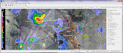
GRLevel3 2.0 Radar Snapshot At 2:29 PM MDT.
Thunderstorms are approaching the Waldo Canyon Fire.
Gusty winds associated with the thunderstorms may fan the
List of evacuations for Waldo Canyon Fire.
Yesterday afternoon 65 mph wind gusts caused the Waldo Canyon Fire to explode on the door steps of Colorado Springs, Colorado. An estimated 32,000 people were evacuated out of their homes in Colorado Springs last night as the fire approached the city. The US Air Force Academy has been evacuated as well and is threatened by the fire.
The Truth Is Stranger Than Fiction!
My Web Page Is Best Viewed With Google Chrome.


Comments
Post a Comment
Your comments, questions, and feedback on this post/web page are welcome.