Posts

My Blog Archive List (July 2010 - August 2025).

Show more

Cannon AFB (KFDX) Radar Outage

Updated 10/01/2025 11am The Cannon Air Force Base (KFDX) WSR-88D will remain inoperable for an extended period due to a hardware failure at the site. Parts have been ordered. There is currently no estimate on when the radar will return to service. KFDX radar is the only radar coverage for portions of eastern New Mexico. However, you may find KPUX, KAMA, KLBB, and KMAF radars useful. If you have questions or concerns, please contact Cannon AFB Public Affairs at 575-784-4131.

Viewing My Web Page

If you are viewing my web page on your cell phone, then be sure and click on the three white bars located in the top left-hand corner of the page (only visible on your phone). This is the menu bar, and it opens up additional links and graphics. Such as forecast maps, severe weather outlooks, current conditions, radar and satellite links, and more.

Slight Risk Severe T-Storms Today - Dry Lightning Threat Across Plains & Mtn's.

Image
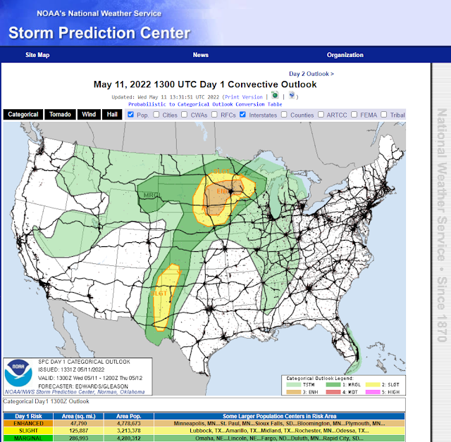
Storm Prediction Center (SPC) Severe Weather Outlook Today, Today's Tornado Outlook. Today's Severe T-Storm Wind Outlook. Today's Hail Outlook. NWS Midland Severe Weather Outlook Today. NWS Albuquerque Severe Weather Outlook Today. Surface Dew Point Temperatures. (At 8:30 AM MDT Wednesday Morning). 24-Hour Rainfall Totals  (As Of 8:30 AM MDT Wednesday). Isolated To Scattered Severe T-Storms Today And This Evening. A broken line of multicellular thunderstorms developed Tuesday afternoon and stretched from west of Jal northeast to northeast of Tatum. Locally heavy rainfall was indicated by rainfall southeast of Tatum where estimates were close to 5.00". This is likely overdone due to hail contamination in the radar return but no doubt heavy rains did fall from these severe thunderstorms. A Personal Weather Station (PWS) measured .72" of rainfall north of Hobbs and a CoCoRaHS Station southwest of Hobbs measured .64" from yesterday's thunderstorms. This morni...

Current US Hazardous Weather Watch/Warning Map

New Mexico

Eddy County

Guadalupe Mtns Eddy & Culberson County

Chaves County Plains & Mtn's

Lea County

Lincoln County

Otero County

Pagosa Springs, Colorado Flooding Oct 12, 2025

Arizona Flooding - Oct 12, 2025

🔴 Live 24/7 National Weather Radar & Alerts, Weather Intensity Score & YallBot!

Ruidoso Live Webcam

Ski Apache Webcam Live Link

Ski Apache Webcam Live Link
Click On The Image To Open It Up

Cloudcroft Live Webcam

Roswell Live EarthCam

New Mexico Weather Tweets

Average Daily High/Low Temperatures & Rainfall/Snowfall

My Rainfall Totals. 2.1 NNW Downtown Carlsbad, NM.

My Favorite Blog List.

Substack

Disclaimer

This blog and its contents are for informational purposes only! Always have multiple sources of information available to rely upon during severe weather. Do not rely solely on the Internet. Be weather-aware, plan ahead, have a backup plan, and be ready to act before severe weather strikes your location.