Current Date & Time

Cold Start To May!

Click On The Maps To Enlarge Them.
My SE NM Radar Snapshot At 8:32 AM MDT.
My SE NM Radar Snapshot At 8:38 MDT.

Feels More Like March 1st Than May 1st.

A strong late season cold front has brought a much colder airmass to the state this morning. The two radar snapshot images above were captured off of the "My SE NM Radar Page" that I have running on this web site. I checked the "Winterize" box to capture the rain and snow.

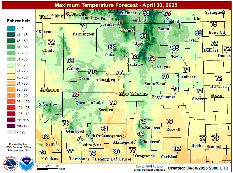
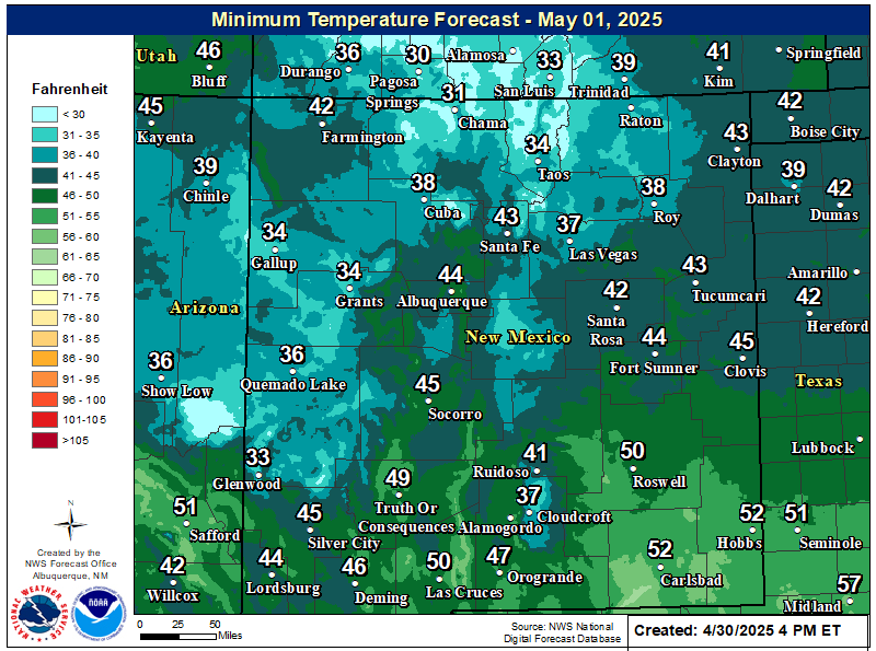
Yes, snow is falling over parts of the state this morning. 1"-2" is reported to be on the grassy surfaces in Las Vegas. Today will be much cooler across SE NM with most of our afternoon high temps ranging from the upper 50's to the low 60's. Tonight will be unseasonable cold with low temps tomorrow morning mostly in the mid-upper 30's. Low temps Tuesday morning will be in the low-mid 30's with some places experiencing a late season freeze.

The Truth Is Stranger Than Fiction!

Comments

  1. I'm trying out a new comment feature. You can leave a comment about my web page, my daily blogs, our local weather or national weather. Tell me what you think.

    ReplyDelete
  2. Testing a new comments addition to my web page.

    ReplyDelete
  3. NWS Office in Albuquerque has issued a Freeze Warning valid from 9 pm tonight through 9 am Mon morning for most of N-C-E NM, Low temps in the Roswell area tom morning upper 20's to low 30's.

    http://forecast.weather.gov/wwamap/wwatxtget.php?cwa=abq&wwa=freeze%20warning

    ReplyDelete
  4. NWS Midland has issued a Freeze Watch for Eddy & Lea Co's for Monday night into Tuesday morning. Our low temps Tue morning forecast to be in the upper 20's to low 30's.

    http://forecast.weather.gov/wwamap/wwatxtget.php?cwa=maf&wwa=freeze+watch

    ReplyDelete
  5. A Freeze Warning has been issued for Chaves-Eddy-Lea Counties for tonight into tomorrow morning. Low temperatures are forecast to range from the upper 20's to the low 30's. Protect those plants and pets.

    http://forecast.weather.gov/wwamap/wwatxtget.php?cwa=maf&wwa=freeze%20warning

    ReplyDelete
  6. Looks like our high temps in SE NM will flirt with 100 this weekend...dry, dry. #nmwx

    ReplyDelete
  7. Next week not looking good for #NM. Critical Fire Wx Condts return Sun-Wed. http://1.usa.gov/m1Z05p #nmwx #nmfire Rain, forgot what it is.

    ReplyDelete
  8. My last measurable rainfall here at my home in Carlsbad, NM was Feb 3rd with .02" of rainfall. A disappointing .23" since Jan 1st, and only .36" since last Oct 1st. It is incredibly dry!

    ReplyDelete
  9. At 4:45 AM MDT this morning my temp here in Carlsbad, NM is 75, with a relative humidity value of a whopping 3%. Its unbelievably dry!

    ReplyDelete
  10. At 4:45 AM MDT this morning my temp here in Carlsbad, NM is 75, with a relative humidity value of a whopping 3%. Its unbelievably dry!

    ReplyDelete
  11. We have a slight chance for a few t-storms this weekend. This may end up being a a curse instead of a blessing. Right now it appears that moisture will be lacking, so these t-storms may be the high based, dry type...producing lots of wind and lightning but little rainfall.

    ReplyDelete

Post a Comment

Your comments, questions, and feedback on this post/web page are welcome.

My Blog Archive List (July 2010 - August 2025).

Show more

My Current Weather Conditions

MY CoCoRaHS Precipitation Data

NWS Albuquerque 2026 Winter Outlook (Updated Nov 3rd).

NWS Midland Web Page

NWS Midland Web Page
Click On The Map To Open It Up

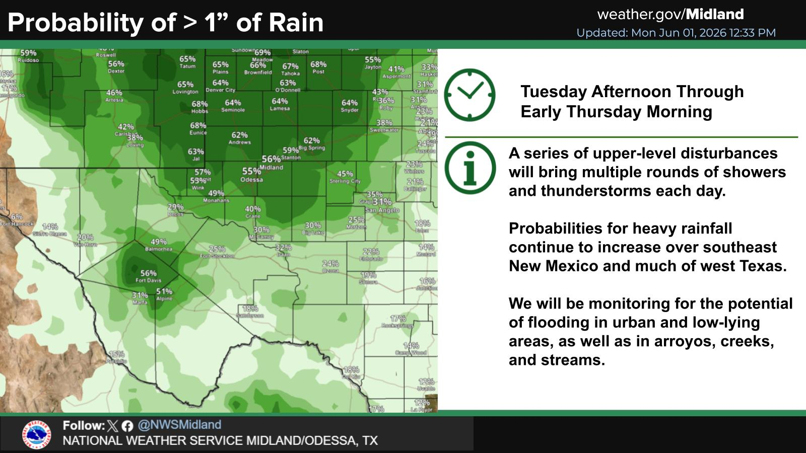
SE New Mexico & West Texas Precipitation Forecasts

Eddy County

Guadalupe Mtns Eddy & Culberson County

Lea County

NWS Midland Forecast High Temperatures Today

NWS Midland Forecast Low Temperatures Tonight

NWS Midland Peak Wind Gust Forecast

NWS Midland Graphic Forecast

NWS Midland Graphic Forecast
Below normal highs today with temperatures in the upper 40s to mid 50s. Clouds remain across most areas today with light drizzle possible.

NWS Albuquerque Web Page

NWS Albuquerque Web Page
Click On The Map To Open It Up

NWS Albuquerque New Mexico Precipitation Forecasts

New Mexico

Chaves County Plains & Mtn's

Lincoln County

NWS Albuquerque Hazardous Weather Outlook

NWS Albuquerque Hazardous Weather Outlook

NWS Albuquerque Forecast High Temperatures Today

NWS Albuquerque Forecast Low Temperatures Tonight

NWS Albuquerque Wind Chill Forecast

NWS Albuquerque Peak Wind Gust Forecast

NWS Albuquerque Graphic Forecast

NWS Albuquerque Graphic Forecast
Increasing south to southwest winds are expected across some parts of northern and central NM Tuesday ahead of an approaching storm system. Some difficult crosswinds on east to west oriented roadways. Unsecured objects may blow around.

NWS Albuquerque Graphic Forecast

NWS Albuquerque Graphic Forecast
Calmer weather continues today before the next storm brings rain and mountain snow chances across western and central New Mexico Tuesday evening through Wednesday morning. Another storm is poised to bring rain and mountain snow chances to northwest and north central New Mexico Friday.

NWS El Paso Web Page

Southern New Mexico & Far West Texas Precipitation Forecasts

Texas

Otero County

NWS El Paso Hazardous Weather Outlook

NWS El Paso Hazardous Weather Outlook
Click On The Image To See The Rest Of The Outlooks

NWS El Paso Hazardous Weather Outlook

NWS El Paso Hazardous Weather Outlook
Click On The Image To See The Rest Of The Outlooks

NWS El Paso Forecast High Temperatures Today

NWS El Paso Forecast Low Temperatures Tonight

NWS El Paso Wind Chill Forecast

NWS El Paso Peak Wind Gust Forecast

NWS El Paso Graphic Forecast

NWS El Paso Graphic Forecast
A cold front will move across the region tonight and that will give us high temperatures on Monday a little below average. Our winds will be light. Most of us will see plenty of sun, but some lower clouds will sneak into Otero and Hudspeth Counties behind the cold front.

NWS Lubbock Web Page

NWS Lubbock Web Page
Click On The Map To Open It Up

NWS Lubbock South Plains Precipitation Forecasts

NWS Lubbock Hi Temperature Forecast Today

NWS Lubbock Low Temperature Forecast Tomight

NWS Lubbock Graphic Forecast

NWS Lubbock Graphic Forecast
Fog is likely across the region through late morning. While the fog will lift, clouds will remain through the rest of the day and through the night. This will keep highs near 50 and lows in the upper 30s to mid 40s.

NWS Lubbock Graphic Forecast

NWS Lubbock Graphic Forecast
After starting off foggy and cool, the week will eventually warm into the 60s. Shower and thunderstorm chances return Thursday.

My Rainfall Totals - 2.1 NNW Downtown Carlsbad

My Rainfall Totals - 2.1 NNW Downtown Carlsbad

My Seasonal Snowfall Totals - 2.1 NNW Downtown Carlsbad

My Seasonal Snowfall Totals - 2.1 NNW Downtown Carlsbad

Disclaimer

This blog and its contents are for informational purposes only! Always have multiple sources of information available to rely upon during severe weather. Do not rely solely on the Internet. Be weather-aware, plan ahead, have a backup plan, and be ready to act before severe weather strikes your location.