Posts

Showing posts from December, 2015

Current Date & Time

Our Home & Three Days Later Our Roads Are Still A Mess In SE NM.

Image
Blog Updated 3:55 PM MST. Carlsbad, New Mexico. 12-27-2015. Carlsbad, New Mexico. 12-28-2015. Carlsbad, New Mexico. 12-29-2015. St. Hwy 128 Near The WIPP Cutoff. St. Hwy 128 Near The WIPP Cutoff. St. Hwy 31 East Of Loving, New Mexico. St. Hwy 31 East Of Loving, New Mexico. Otis Southeast Of Carlsbad, New Mexico. Carlsbad, New Mexico. Carlsbad Walmart Parking Lot. Carlsbad Looking West Down Church St. At C-Hill. Artesia Still Digging Out From Winter Storm. The Truth Is Stranger Than Fiction!

Some Say It Never Snows In SE New Mexico - It Did.

Image
Blog Updated @ 5:15 PM MST Tuesday, Dec 29, 2015. Carlsbad, New Mexico This Morning. Courtesy of Daniel Onsurez.   Courtesy of Jaclyn West.  Courtesy Of Michelle Huber Carey & Brent Jackson. Artesia, New Mexico This Morning. Courtesy Of David West. 15 Miles East Of Artesia, New Mexico. Courtesy Of David West. Courtesy Of Darla Vernon. Courtesy Of Barry Price. Courtesy Of Rodney Standard. Our Grandkids In Artesia This Morning. Atoka 5 Miles South Of Artesia. Courtesy Of My Mother Frances Calloway. Courtesy Of Carrie Greenwood.  Clovis New Mexico This Morning. Courtesy Of Cindy Galloway Fogerson. Stranded In Deep Snow 42 Miles From Home. Courtesy Of Sylvia Heron. This one just speaks volumes about our Blizzard. Jackie Heron ended up getting stuck 42 miles from Artesia in the deep snow. He then nearly ran out of gas and became str...

Historic Blizzard Shuts Down Much Of New Mexico - December 27, 2015.

Image
Our Home In Carlsbad, New Mexico. Courtesy Of Rebecca Baldwin. 12" On The Ground With 4 Foot Drifts In South Carlsbad, New Mexico. Courtesy Of My Daughter In Artesia, New Mexico. 14" On The Ground With 2 Foot to 3 Foot Drifts. Carlsbad, New Mexico Fire Station #4 This Morning. 41/2 Drifts. Blog Updated @ 6:29 PM MST This Afternoon. Gov. Susana Martinez Declares State Of Emergency In Response To Statewide Snow Storm. This courtesy of the  Roswell Daily Record . "Gov. Susana Martinez declares state of emergency in response to statewide snow storm. On Sunday, Gov. Susana Martinez declared a state of emergency in response to the massive statewide snow storm that continues to impact the entire state. In some parts of New Mexico, more than 16 inches of snow has fallen with drifts as high as eight feet, making roads impassable in several counties. High winds and blowing snow have led to extremely dangerous and life-threatening conditions in ...

My Blog Archive List (July 2010 - August 2025).

Show more

My Current Weather Conditions

MY CoCoRaHS Precipitation Data

NWS Albuquerque 2026 Winter Outlook (Updated Nov 19th).

NWS Midland Web Page

NWS Midland Web Page
Click On The Map To Open It Up

SE New Mexico & West Texas Precipitation Forecasts

Eddy County

Guadalupe Mtns Eddy & Culberson County

Lea County

NWS Midland Hazardous Weather Outlook

NWS Midland Hazardous Weather Outlook
Click On The Image To See The Rest Of The Outlooks

NWS Midland Hazardous Weather Outlook

NWS Midland Hazardous Weather Outlook

NWS Midland Hazardous Weather Outlook

NWS Midland Hazardous Weather Outlook
Click On The Image To See The Rest Of The Outlooks

NWS Midland Forecast High Temperatures Today

NWS Midland Forecast Low Temperatures Tonight

NWS Midland Peak Wind Gust Forecast

NWS Midland Graphic Forecast

NWS Midland Graphic Forecast
Following a front Saturday evening/Saturday night, temperatures fall below normal across southeast New Mexico and west Texas. Highs stay below normal throughout next week thanks to reinforcing shots of cold air. A few locations (mainly in the northern Permian Basin, SE New Mexico, and in the Davis Mountains) may see their first freeze Monday and/or Wednesday mornings.

NWS Albuquerque Web Page

NWS Albuquerque Web Page
Click On The Map To Open It Up

NWS Albuquerque New Mexico Precipitation Forecasts

New Mexico

Chaves County Plains & Mtn's

Lincoln County

NWS Albuquerque Hazardous Weather Outlook

NWS Albuquerque Hazardous Weather Outlook

NWS Albuquerque Forecast High Temperatures Today

Today's High Temperature Difference From Climatology

NWS Albuquerque Forecast Low Temperatures Tonight

Tonight's Low Temperature Difference From Climatology

NWS Albuquerque Wind Chill Forecast

NWS Albuquerque Peak Wind Gust Forecast

NWS Albuquerque Graphic Forecast

NWS Albuquerque Graphic Forecast
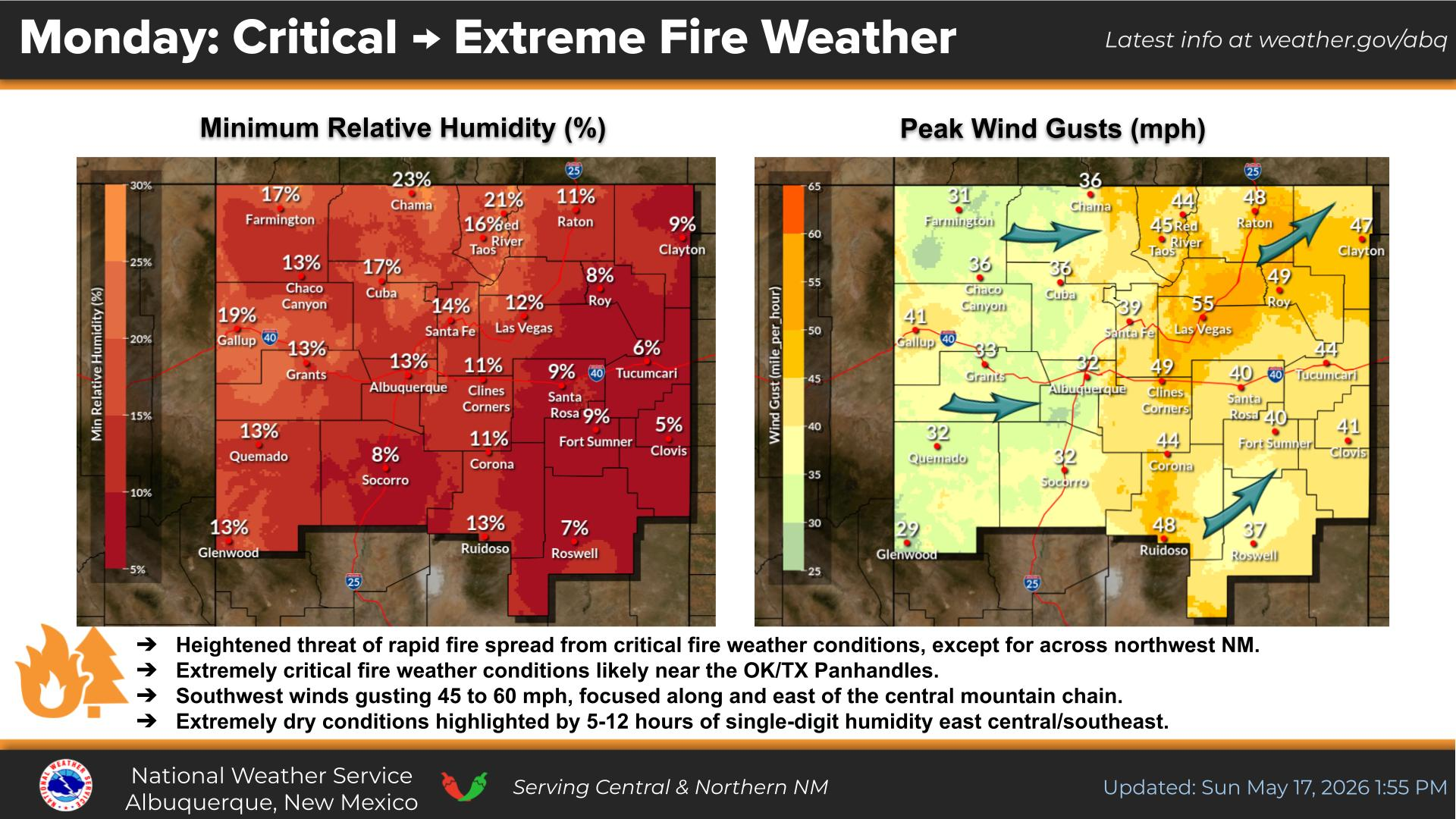
A Wind Advisory has been issued for the Sacramento Mountains from 11 AM to 5 PM MST due to expected sustained west winds of 30 to 35 mph with gusts of up to 55 mph.

NWS Albuquerque Graphic Forecast

NWS Albuquerque Graphic Forecast
Gusty westerly to northwesterly winds are forecast across much of NM this afternoon. Crosswinds will yield difficult travel conditions on area highways for high profile vehicles.

NWS Albuquerque Graphic Forecast

NWS Albuquerque Graphic Forecast
A cold front brings light snow accumulations to the high terrain of western and northern NM today. Minor winter travel impacts from slick roads are likely through high mountain passes. Brief snowfall could occur as low as 6,000 feet.

NWS Albuquerque Forecast Grpahics

NWS Albuquerque Forecast Grpahics
Colder temperatures sweep in behind a cold front Saturday night into Sunday morning when many areas are forecast to see a hard freeze.

NWS Albuquerque Graphic Forecast

NWS Albuquerque Graphic Forecast
Temperatures drop this weekend and remain near to slightly below normal through most of next week. Mornings will be chilly with temps below freezing in most areas.

NWS El Paso Web Page

Southern New Mexico & Far West Texas Precipitation Forecasts

Texas

Otero County

NWS El Paso Hazardous Weather Outlook

NWS El Paso Hazardous Weather Outlook
Click On The Image To See The Rest Of The Outlooks

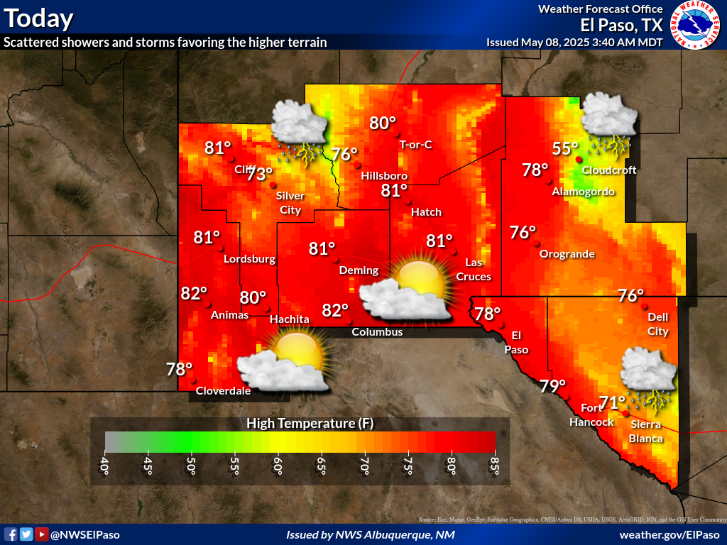
NWS El Paso Forecast High Temperatures Today

NWS El Paso Forecast Low Temperatures Tonight

NWS El Paso Wind Chill Forecast

NWS El Paso Peak Wind Gust Forecast

NWS El Paso Graphic Forecast

NWS El Paso Graphic Forecast
Moderate mid level winds will increase towards noon today and last until late afternoon around sunset. Wind gusts of 40-50 mph are expected, mainly north of US Highway 82.

NWS El Paso Graphic Forecast

NWS El Paso Graphic Forecast
Dependent on how early the winds die down Sunday morning, parts of New Mexico could see their first freeze of the season.

NWS Lubbock Web Page

NWS Lubbock Web Page
Click On The Map To Open It Up

NWS Lubbock South Plains Precipitation Forecasts

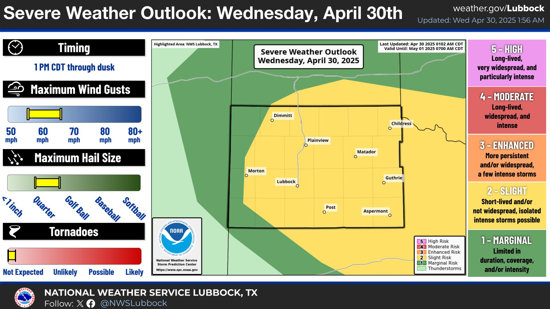
NWS Lubbock Hazardous Weather Outlook

NWS Lubbock Hazardous Weather Outlook

NWS Lubbock Hazardous Weather Outlook
Click On The Image To See The Rest Of The Outlooks

NWS Lubbock Hazardous Weather Outlook

NWS Lubbock Hazardous Weather Outlook
Click On The Image To See The Rest Of The Outlooks

NWS Lubbock Hazardous Weather Outlook

NWS Lubbock Hi Temperature Forecast Today

NWS Lubbock Low Temperature Forecast Tomight

NWS Lubbock Graphic Forecast

NWS Lubbock Graphic Forecast
Isolated showers and thunderstorms will be possible late this morning through early this afternoon, primarily for areas off the Caprock. While the severe weather threat remains relatively low, an isolated storm could produce a brief strong wind gust or quarter sized hail.

NWS Lubbock Graphic Forecast

NWS Lubbock Graphic Forecast
Areas of patchy to localized pockets of dense fog will continue through Saturday morning across the Caprock, clearing by mid-morning. Thereafter, sunny and warmer highs are expected with the return of an isolated storm or two off the Caprock. The severe weather threat remains low though strong winds may be possible. #lubwx #txwx

NWS Lubbock Graphic Forecast

NWS Lubbock Graphic Forecast
Much cooler weather arrives Sunday followed by a long-overdue and widespread freeze for Monday morning with cooler afternoon highs. Chances for rain showers return late Monday into Tuesday morning.

My Rainfall Totals - 2.1 NNW Downtown Carlsbad

My Rainfall Totals - 2.1 NNW Downtown Carlsbad

My Seasonal Snowfall Totals - 2.1 NNW Downtown Carlsbad

My Seasonal Snowfall Totals - 2.1 NNW Downtown Carlsbad

Disclaimer

This blog and its contents are for informational purposes only! Always have multiple sources of information available to rely upon during severe weather. Do not rely solely on the Internet. Be weather-aware, plan ahead, have a backup plan, and be ready to act before severe weather strikes your location.