Christmas Storm Track Still Up In The Air.
A highly complex, and deep upper-level Winter Storm was centered just off the southwestern coast of Alaska this morning. This storm has undergone some reorganization over the past 24-hours and is becoming more negatively tilted. A trough of low pressure stretches southeast from the center of the low to the Pacific Northwest Coastline. A massive ridge of high pressure is located north of the storm, north of Alaska.
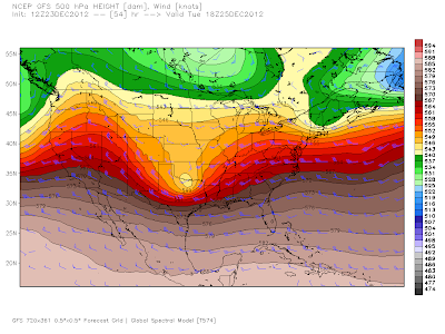
The U.S. GFS Model Forecast.
Valid At 5 PM Christmas Eve.
This Mornings 12Z/5 AM MST 500 MB Forecast.
Valid At 5 AM MST Christmas Morning.
This Mornings 12Z/5 AM MST GFS 500 MB Forecast.
Valid At 11 AM MST Christmas Morning.
This Mornings 12Z/5 AM MST 1000-500 MB Forecast.
Valid At 5 AM MST Christmas Morning.
This Mornings 12Z/5 AM MST GFS Max Snow Depth Forecast.
Valid At 5 PM MST Christmas Evening.
This mornings run of the U.S. GFS model drops a short wave trough of low pressure into the Great Basin by sunset Christmas Eve. This wave then deepens over eastern New Mexico and west Texas into a closed upper-level low (or attempts to anyway) by sunrise Christmas morning. By around noontime Christmas Day the storm is centered near Dallas, Texas.
Notice how the GFS model positions the surface low near Big Springs, Texas by sunrise Christmas morning. This would be too far east of southeastern New Mexico to give us any chance of snow for Christmas if this model forecast pans out.
The NCEP NAM Model Forecast.
Valid At 5 PM MST Christmas Eve.
This Mornings 12Z/5 AM MST NCEP NAM 500 MB Forecast.
Valid At 5 AM MST Christmas Morning.
This Mornings 12Z/5 AM MST NCEP NAM 500 MB Forecast.
Valid At 11 AM MST Christmas Morning.
This Mornings 12Z/GFS Temp Anomaly Forecast.
Valid At 5 PM MST Christmas Evening.
This Mornings 12Z/5 AM MST NCEP NAM Snow Depth Forecast.
Valid At 5 PM MST Christmas Evening.
Valid At 5 PM MST Christmas Evening.
This mornings run of the NAM model has the center of the upper-level low over the northern Texas Panhandle by sunrise Christmas morning. By around noontime it moves it steadily eastward to southeastern Oklahoma.
Personally, I think that both the GFS, and the NAM models, are too far east with this storm with their Christmas forecast positions. I also think that later model runs will shift the storm track further west. Just my opinion. However, should this forecast model be right...check out the snowfall totals for northern Oklahoma, 18" - 24".
The Canadian (CMC) Model Forecast.
Valid At 5 AM MST Christmas Morning.
This mornings run of the Canadian (CMC) model has more of a westward track of the inbound short wave trough of low pressure. Wrap around moisture behind the storm would produce light snow over parts of eastern New Mexico Christmas evening.
The European (ECMWF) Model Forecast.
Valid At 5 AM MST Christmas Morning.
Its been rather disappointing to watch the European (ECMWF) model forecasts this past week, normally this model is one of the more stable and reliable models to watch. This model has just been all over the place with this storm.This mornings run has once again shifted the center of the upper-level storm back westward (from northeastern Texas) to near Clovis by sunrise Christmas morning. This is just crazy, its been a while since I have seen such wild variations in the models forecasts.
Today & Christmas Eve.
A deck of mid-high level clouds kept our high temps from climbing up to forecast levels yesterday. A steady stream of this mid-high level moisture continues to stream northeastward into the area from the southwest, and may help keep this afternoons highs a little lower than forecast also. We are forecast to reach the low 70's today.
An arctic cold front will surge southward down the eastern plains of the state into southeastern New Mexico by Christmas morning. Just how soon this colder airmass arrives is still up in the air because the models haven't resolved their timing issues with this inbound Winter Storm yet.
For now, we are still on track to see colder temps on Christmas with current forecasts indicating the 40's for most of southeastern New Mexico. If the storm tracks further to the west then parts of eastern New Mexico could see some light snow Christmas Day into Christmas Evening.
If we are going to see a White Christmas in southeastern New Mexico this year the storm is going to have to shift much further to the west than the models are currently indicating.
Are you confused by all of this...welcome to the crowd, there are lots of us weather folks scratching our heads with this one. More later.
The Truth Is Stranger Than Fiction!
My Web Page Is Best Viewed With Google Chrome.


Comments
Post a Comment
Your comments, questions, and feedback on this post/web page are welcome.